Holtland geodata
Holtland (Lower Saxony) is a seat of a fourth-order administrative division; located in Germany in Europe/Berlin (GMT+2) time zone. With population of 2,248 people, there are 4743 cities with bigger population in this country. Compared to other cities in Germany, 83.5% of cities are located further ↓South; 85.4% of cities are located further →East and 95.2% of cities have higher elevation than Holtland. Note1


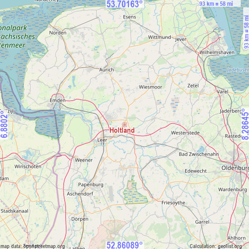
Holtland GPS coordinates[2]
53° 16' 59.988" North, 7° 34' 59.988" East
| Map corner | latitude | longitude |
|---|---|---|
| Upper-left | 53.70163°, | 6.8802° |
| Center: | 53.28333°, | 7.58333° |
| Lower-right: | 52.86089°, | 8.28645° |
| Map W x H: | 93.5×93.5 km | = 58.1×58.1mi |
| max Lat: | 55.01917° ⇑16.5% North |
| Holtland: | 53.28333° |
| min Lat: | ⇓83.5% South 47.40724° |
| min Long | Holtland | max Long |
| 5.92978° | 7.58333° | 14.98853° |
| W 14.6%⇐ | ⇒85.4% E |
Elevation
Elevation of Holtland is 8 m = 26 ft, and this is 241.1 m = 791 ft below average elevation for this country.
| Max E: |
1256 m = 4121 ft | 95.2% |
| Avg. | 249.1 m = 817 ft | |
| Holtland | 8 m = 26 ft | |
Min E: |
-5 m = -16 ft | 4.8% |
See also: Germany elevation on elevation.city.
Geographical zone
Holtland is located in North temperate zone (between Tropic of Cancer and the Arctic Circle). Distance of this North polar circle is 1476.6 km =917.5 mi to North.| Distance of | km | miles | from Holtland |
|---|---|---|---|
| North Pole | 4082.5 | 2536.7 | to North |
| Arctic Circle | 1476.6 | 917.5 | to North |
| Tropic Cancer | 3318.6 | 2062.1 | to South |
| Equator | 5924.6 | 3681.4 | to South |


Nearby cities:
15 places around Holtland: (largest is in red/bold)
• Apen
16.2 km =10.1 mi,  117°
117°
• Barßel
16.8 km =10.4 mi,  138°
138°
• Brinkum
2.2 km =1.4 mi,  210°
210°
• Detern
10.2 km =6.3 mi, 143°
• Filsum
5.5 km =3.4 mi,  147°
147°
• Firrel
7.8 km =4.8 mi,  44°
44°
• Hesel
2.2 km =1.4 mi,  30°
30°
• Jemgum
13.4 km =8.3 mi,  262°
262°
• Leer
10 km =6.2 mi,  234°
234°
• Mittegroßefehn
12.1 km =7.5 mi,  354°
354°
• Neukamperfehn
6.1 km =3.8 mi, 346°
• Nortmoor
4.2 km =2.6 mi,  190°
190°
• Ostrhauderfehn
16.8 km =10.4 mi,  172°
172°
• Schwerinsdorf
5.9 km =3.7 mi,  59°
59°
• Wiesmoor
17.9 km =11.1 mi, 33°
Sources, notices
• [Note1] Compared only with cities in Germany existing in our database
• [Src1] Map data: © OpenStreetMap contributors (CC-BY-SA)
• [Src2] Other city data from geonames.org with taken over terms of usage.
• [Src3] Geographical zone / Annual Mean Temperature by Robert A. Rohde @ Wikipedia
