Neukamperfehn geodata
Neukamperfehn (Lower Saxony) is a seat of a fourth-order administrative division; located in Germany in Europe/Berlin (GMT+2) time zone. With population of 1,587 people, there are 5703 cities with bigger population in this country. Compared to other cities in Germany, 84% of cities are located further ↓South; 85.8% of cities are located further →East and 99.1% of cities have higher elevation than Neukamperfehn. Note1


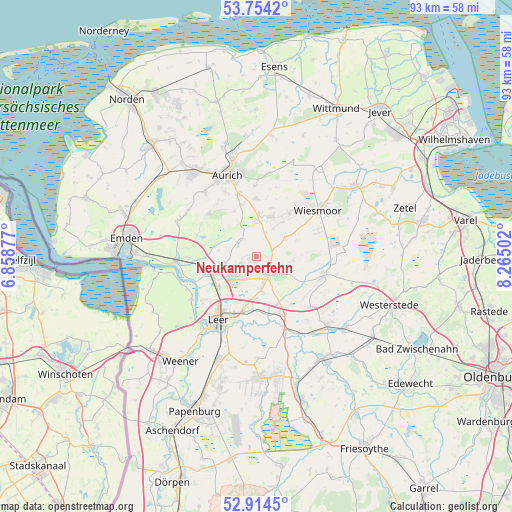
Neukamperfehn GPS coordinates[2]
53° 20' 11.112" North, 7° 33' 42.804" East
| Map corner | latitude | longitude |
|---|---|---|
| Upper-left | 53.7542°, | 6.85877° |
| Center: | 53.33642°, | 7.56189° |
| Lower-right: | 52.9145°, | 8.26502° |
| Map W x H: | 93.4×93.4 km | = 58×58mi |
| max Lat: | 55.01917° ⇑16% North |
| Neukamperfehn: | 53.33642° |
| min Lat: | ⇓84% South 47.40724° |
| min Long | Neukamperfehn | max Long |
| 5.92978° | 7.56189° | 14.98853° |
| W 14.2%⇐ | ⇒85.8% E |
Elevation
Elevation of Neukamperfehn is 0 m = 0 ft, and this is 249.1 m = 817 ft below average elevation for this country.
| Max E: |
1256 m = 4121 ft | 99.1% |
| Avg. | 249.1 m = 817 ft | |
| Neukamperfehn | 0 m = 0 ft | |
Min E: |
-5 m = -16 ft | 0.9% |
See also: Germany elevation on elevation.city.
Geographical zone
Neukamperfehn is located in North temperate zone (between Tropic of Cancer and the Arctic Circle). Distance of this North polar circle is 1470.7 km =913.9 mi to North.| Distance of | km | miles | from Neukamperfehn |
|---|---|---|---|
| North Pole | 4076.6 | 2533.1 | to North |
| Arctic Circle | 1470.7 | 913.9 | to North |
| Tropic Cancer | 3324.5 | 2065.7 | to South |
| Equator | 5930.5 | 3685 | to South |


Nearby cities:
15 places around Neukamperfehn: (largest is in red/bold)
• Apen
20.7 km =12.9 mi,  130°
130°
• Aurich
15.7 km =9.8 mi,  340°
340°
• Brinkum
7.8 km =4.8 mi,  177°
177°
• Detern
16 km =9.9 mi,  152°
152°
• Filsum
11.4 km =7.1 mi,  157°
157°
• Firrel
7 km =4.3 mi,  92°
92°
• Friedeburg
22 km =13.7 mi,  54°
54°
• Hesel
4.8 km =3 mi, 147°
• Holtland
6.1 km =3.8 mi,  166°
166°
• Jemgum
14.2 km =8.8 mi,  236°
236°
• Leer
13.4 km =8.3 mi,  209°
209°
• Mittegroßefehn
6.1 km =3.8 mi,  2°
2°
• Nortmoor
10.1 km =6.3 mi, 176°
• Schwerinsdorf
7.2 km =4.5 mi,  113°
113°
• Wiesmoor
14.5 km =9 mi, 51°
Sources, notices
• [Note1] Compared only with cities in Germany existing in our database
• [Src1] Map data: © OpenStreetMap contributors (CC-BY-SA)
• [Src2] Other city data from geonames.org with taken over terms of usage.
• [Src3] Geographical zone / Annual Mean Temperature by Robert A. Rohde @ Wikipedia
