Schwerinsdorf geodata
Schwerinsdorf (Lower Saxony) is a seat of a fourth-order administrative division; located in Germany in Europe/Berlin (GMT+2) time zone. With population of 762 people, there are 8038 cities with bigger population in this country. Compared to other cities in Germany, 83.8% of cities are located further ↓South; 83.7% of cities are located further →East and 94.8% of cities have higher elevation than Schwerinsdorf. Note1


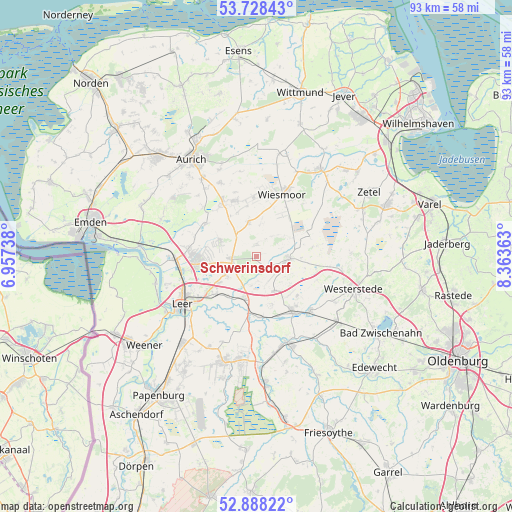
Schwerinsdorf GPS coordinates[2]
53° 18' 37.404" North, 7° 39' 37.8" East
| Map corner | latitude | longitude |
|---|---|---|
| Upper-left | 53.72843°, | 6.95738° |
| Center: | 53.31039°, | 7.6605° |
| Lower-right: | 52.88822°, | 8.36363° |
| Map W x H: | 93.4×93.4 km | = 58×58mi |
| max Lat: | 55.01917° ⇑16.2% North |
| Schwerinsdorf: | 53.31039° |
| min Lat: | ⇓83.8% South 47.40724° |
| min Long | Schwerinsdorf | max Long |
| 5.92978° | 7.6605° | 14.98853° |
| W 16.3%⇐ | ⇒83.7% E |
Elevation
Elevation of Schwerinsdorf is 9 m = 30 ft, and this is 240.1 m = 788 ft below average elevation for this country.
| Max E: |
1256 m = 4121 ft | 94.8% |
| Avg. | 249.1 m = 817 ft | |
| Schwerinsdorf | 9 m = 30 ft | |
Min E: |
-5 m = -16 ft | 5.2% |
See also: Germany elevation on elevation.city.
Geographical zone
Schwerinsdorf is located in North temperate zone (between Tropic of Cancer and the Arctic Circle). Distance of this North polar circle is 1473.6 km =915.7 mi to North.| Distance of | km | miles | from Schwerinsdorf |
|---|---|---|---|
| North Pole | 4079.5 | 2534.9 | to North |
| Arctic Circle | 1473.6 | 915.7 | to North |
| Tropic Cancer | 3321.6 | 2063.9 | to South |
| Equator | 5927.6 | 3683.2 | to South |


Nearby cities:
15 places around Schwerinsdorf: (largest is in red/bold)
• Apen
14 km =8.7 mi,  138°
138°
• Barßel
16.7 km =10.4 mi,  159°
159°
• Brinkum
7.9 km =4.9 mi,  232°
232°
• Detern
11.3 km =7 mi,  175°
175°
• Filsum
7.9 km =4.9 mi,  195°
195°
• Firrel
2.6 km =1.6 mi,  9°
9°
• Hesel
4.2 km =2.6 mi,  253°
253°
• Holtland
5.9 km =3.7 mi,  239°
239°
• Jemgum
19.1 km =11.9 mi,  255°
255°
• Leer
15.9 km =9.9 mi, 236°
• Mittegroßefehn
11 km =6.8 mi,  325°
325°
• Neukamperfehn
7.2 km =4.5 mi,  293°
293°
• Nortmoor
9.3 km =5.8 mi,  219°
219°
• Westerstede
18.7 km =11.6 mi,  108°
108°
• Wiesmoor
12.8 km =8 mi,  22°
22°
Sources, notices
• [Note1] Compared only with cities in Germany existing in our database
• [Src1] Map data: © OpenStreetMap contributors (CC-BY-SA)
• [Src2] Other city data from geonames.org with taken over terms of usage.
• [Src3] Geographical zone / Annual Mean Temperature by Robert A. Rohde @ Wikipedia
