Dillingen geodata
Dillingen (Saarland) is a populated place; located in Germany in Europe/Berlin (GMT+2) time zone. With population of 21,526 people, there are 704 cities with bigger population in this country. Compared to other cities in Germany, 77.8% of cities are located further ↑North; 96.2% of cities are located further →East and 54.9% of cities have higher elevation than Dillingen. Note1


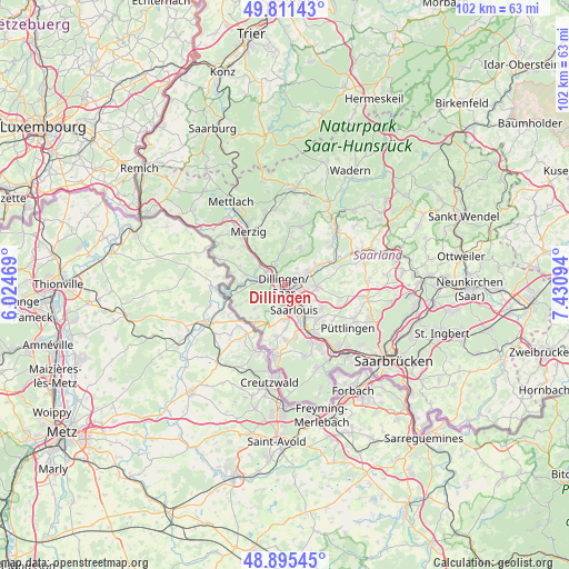
Dillingen GPS coordinates[2]
49° 21' 20.052" North, 6° 43' 40.116" East
| Map corner | latitude | longitude |
|---|---|---|
| Upper-left | 49.81143°, | 6.02469° |
| Center: | 49.35557°, | 6.72781° |
| Lower-right: | 48.89545°, | 7.43094° |
| Map W x H: | 101.8×101.8 km | = 63.3×63.3mi |
| max Lat: | 55.01917° ⇑77.8% North |
| Dillingen: | 49.35557° |
| min Lat: | ⇓22.2% South 47.40724° |
| min Long | Dillingen | max Long |
| 5.92978° | 6.72781° | 14.98853° |
| W 3.8%⇐ | ⇒96.2% E |
Elevation
Elevation of Dillingen is 190 m = 623 ft, and this is 59.1 m = 194 ft below average elevation for this country.
| Max E: |
1256 m = 4121 ft | 54.9% |
| Avg. | 249.1 m = 817 ft | |
| Dillingen | 190 m = 623 ft | |
Min E: |
-5 m = -16 ft | 45.1% |
See also: Germany elevation on elevation.city.
Geographical zone
Dillingen is located in North temperate zone (between Tropic of Cancer and the Arctic Circle). Distance of this North polar circle is 1913.3 km =1188.9 mi to North.| Distance of | km | miles | from Dillingen |
|---|---|---|---|
| North Pole | 4519.2 | 2808.1 | to North |
| Arctic Circle | 1913.3 | 1188.9 | to North |
| Tropic Cancer | 2881.9 | 1790.7 | to South |
| Equator | 5487.8 | 3410 | to South |


Nearby cities:
15 places around Dillingen: (largest is in red/bold)
• Altforweiler
9.2 km =5.7 mi,  189°
189°
• Beckingen
5.3 km =3.3 mi,  337°
337°
• Berus
10.4 km =6.5 mi, 192°
• Bisten
11.4 km =7.1 mi, 187°
• Bous
10.2 km =6.3 mi,  148°
148°
• Ensdorf
7.4 km =4.6 mi, 146°
• Hostenbach
12 km =7.5 mi, 148°
• Merzig
11.7 km =7.3 mi,  326°
326°
• Nalbach
5.1 km =3.2 mi,  52°
52°
• Röchling-Höhe
12.2 km =7.6 mi,  140°
140°
• Saarlouis
5 km =3.1 mi,  159°
159°
• Saarwellingen
5.6 km =3.5 mi,  91°
91°
• Schwalbach
8.9 km =5.5 mi,  133°
133°
• Wadgassen
10.7 km =6.6 mi, 157°
• Wallerfangen
3.4 km =2.1 mi,  201°
201°
Sources, notices
• [Note1] Compared only with cities in Germany existing in our database
• [Src1] Map data: © OpenStreetMap contributors (CC-BY-SA)
• [Src2] Other city data from geonames.org with taken over terms of usage.
• [Src3] Geographical zone / Annual Mean Temperature by Robert A. Rohde @ Wikipedia
