Laupheim geodata
Laupheim (Baden-Württemberg) is a populated place; located in Germany in Europe/Berlin (GMT+2) time zone. With population of 19,012 people, there are 822 cities with bigger population in this country. Compared to other cities in Germany, 92.3% of cities are located further ↑North; 51.8% of cities are located further →East and 89% of cities have lower elevation than Laupheim. Note1
Administrative division(s):
- Level 1: Baden-Württemberg
- Level 2: Tübingen Region
- Level 3: Landkreis Biberach
- Level 4: Laupheim


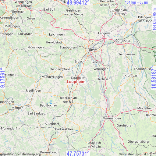
Laupheim GPS coordinates[2]
48° 13' 40.296" North, 9° 52' 43.464" East
| Map corner | latitude | longitude |
|---|---|---|
| Upper-left | 48.69412°, | 9.17561° |
| Center: | 48.22786°, | 9.87874° |
| Lower-right: | 47.75731°, | 10.58187° |
| Map W x H: | 104.2×104.2 km | = 64.7×64.7mi |
| max Lat: | 55.01917° ⇑92.3% North |
| Laupheim: | 48.22786° |
| min Lat: | ⇓7.7% South 47.40724° |
| min Long | Laupheim | max Long |
| 5.92978° | 9.87874° | 14.98853° |
| W 48.2%⇐ | ⇒51.8% E |
Elevation
Elevation of Laupheim is 504 m = 1654 ft, and this is 254.9 m = 836 ft above average elevation for this country.
| Max E: |
1256 m = 4121 ft | 11% |
| Laupheim | 504 m 1654 ft | |
| Avg. | 249.1 m = 817 ft | |
Min E: |
-5 m = -16 ft | 89% |
See also: Germany elevation on elevation.city.
Geographical zone
Laupheim is located in North temperate zone (between Tropic of Cancer and the Arctic Circle). Distance of this North polar circle is 2038.7 km =1266.8 mi to North.| Distance of | km | miles | from Laupheim |
|---|---|---|---|
| North Pole | 4644.6 | 2886 | to North |
| Arctic Circle | 2038.7 | 1266.8 | to North |
| Tropic Cancer | 2756.5 | 1712.8 | to South |
| Equator | 5362.4 | 3332 | to South |


Nearby cities:
15 places around Laupheim: (largest is in red/bold)
• Achstetten
3.7 km =2.3 mi,  21°
21°
• Burgrieden
4.1 km =2.5 mi,  81°
81°
• Dettingen
12.3 km =7.6 mi,  288°
288°
• Erbach
11.2 km =7 mi,  3°
3°
• Ersingen
7.4 km =4.6 mi,  346°
346°
• Griesingen
8.3 km =5.2 mi,  301°
301°
• Hüttisheim
7.4 km =4.6 mi,  39°
39°
• Maselheim
10.5 km =6.5 mi,  178°
178°
• Mietingen
5.2 km =3.2 mi,  162°
162°
• Oberdischingen
8.7 km =5.4 mi,  337°
337°
• Schnürpflingen
9.8 km =6.1 mi,  59°
59°
• Schwendi
9.3 km =5.8 mi,  129°
129°
• Staig
11.6 km =7.2 mi,  46°
46°
• Wain
11.4 km =7.1 mi,  112°
112°
• Öpfingen
8.6 km =5.3 mi,  319°
319°
Sources, notices
• [Note1] Compared only with cities in Germany existing in our database
• [Src1] Map data: © OpenStreetMap contributors (CC-BY-SA)
• [Src2] Other city data from geonames.org with taken over terms of usage.
• [Src3] Geographical zone / Annual Mean Temperature by Robert A. Rohde @ Wikipedia
