Hüttisheim geodata
Hüttisheim (Baden-Württemberg) is a seat of a fourth-order administrative division; located in Germany in Europe/Berlin (GMT+2) time zone. With population of 1,400 people, there are 6077 cities with bigger population in this country. Compared to other cities in Germany, 91.5% of cities are located further ↑North; 50.9% of cities are located further →East and 89.7% of cities have lower elevation than Hüttisheim. Note1
Administrative division(s):
- Level 1: Baden-Württemberg
- Level 2: Tübingen Region
- Level 3: Alb-Donau-Kreis
- Level 4: Hüttisheim


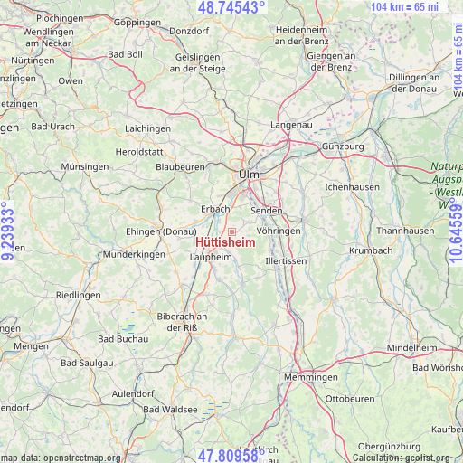
Hüttisheim GPS coordinates[2]
48° 16' 46.74" North, 9° 56' 32.856" East
| Map corner | latitude | longitude |
|---|---|---|
| Upper-left | 48.74543°, | 9.23933° |
| Center: | 48.27965°, | 9.94246° |
| Lower-right: | 47.80958°, | 10.64559° |
| Map W x H: | 104.1×104.1 km | = 64.7×64.7mi |
| max Lat: | 55.01917° ⇑91.5% North |
| Hüttisheim: | 48.27965° |
| min Lat: | ⇓8.5% South 47.40724° |
| min Long | Hüttisheim | max Long |
| 5.92978° | 9.94246° | 14.98853° |
| W 49.1%⇐ | ⇒50.9% E |
Elevation
Elevation of Hüttisheim is 510 m = 1673 ft, and this is 260.9 m = 856 ft above average elevation for this country.
| Max E: |
1256 m = 4121 ft | 10.3% |
| Hüttisheim | 510 m 1673 ft | |
| Avg. | 249.1 m = 817 ft | |
Min E: |
-5 m = -16 ft | 89.7% |
See also: Germany elevation on elevation.city.
Geographical zone
Hüttisheim is located in North temperate zone (between Tropic of Cancer and the Arctic Circle). Distance of this North polar circle is 2033 km =1263.2 mi to North.| Distance of | km | miles | from Hüttisheim |
|---|---|---|---|
| North Pole | 4638.9 | 2882.5 | to North |
| Arctic Circle | 2033 | 1263.2 | to North |
| Tropic Cancer | 2762.3 | 1716.4 | to South |
| Equator | 5368.2 | 3335.6 | to South |


Nearby cities:
15 places around Hüttisheim: (largest is in red/bold)
• Achstetten
4.1 km =2.5 mi,  235°
235°
• Bellenberg
11.3 km =7 mi,  102°
102°
• Burgrieden
5.2 km =3.2 mi,  187°
187°
• Erbach
6.8 km =4.2 mi,  323°
323°
• Ersingen
6.6 km =4.1 mi,  282°
282°
• Illerrieden
8.1 km =5 mi, 97°
• Laupheim
7.4 km =4.6 mi,  219°
219°
• Mietingen
11.2 km =7 mi,  196°
196°
• Oberdischingen
8.4 km =5.2 mi,  285°
285°
• Schnürpflingen
3.8 km =2.4 mi, 101°
• Senden
9 km =5.6 mi,  56°
56°
• Staig
4.3 km =2.7 mi, 58°
• Vöhringen
10.4 km =6.5 mi,  90°
90°
• Wain
11.6 km =7.2 mi,  150°
150°
• Öpfingen
10.4 km =6.5 mi,  274°
274°
Sources, notices
• [Note1] Compared only with cities in Germany existing in our database
• [Src1] Map data: © OpenStreetMap contributors (CC-BY-SA)
• [Src2] Other city data from geonames.org with taken over terms of usage.
• [Src3] Geographical zone / Annual Mean Temperature by Robert A. Rohde @ Wikipedia
