Langgöns geodata
Langgöns (Hesse) is a seat of a fourth-order administrative division; located in Germany in Europe/Berlin (GMT+2) time zone. With population of 12,283 people, there are 1329 cities with bigger population in this country. Compared to other cities in Germany, 52.8% of cities are located further ↑North; 69.5% of cities are located further →East and 52.6% of cities have higher elevation than Langgöns. Note1
Administrative division(s):
- Level 1: Hesse
- Level 2: Regierungsbezirk Gießen
- Level 3: Landkreis Gießen
- Level 4: Langgöns


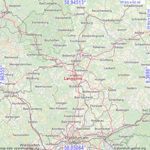
Langgöns GPS coordinates[2]
50° 30' 0" North, 8° 40' 0.012" East
| Map corner | latitude | longitude |
|---|---|---|
| Upper-left | 50.94513°, | 7.96355° |
| Center: | 50.5°, | 8.66667° |
| Lower-right: | 50.05064°, | 9.3698° |
| Map W x H: | 99.5×99.5 km | = 61.8×61.8mi |
| max Lat: | 55.01917° ⇑52.8% North |
| Langgöns: | 50.5° |
| min Lat: | ⇓47.2% South 47.40724° |
| min Long | Langgöns | max Long |
| 5.92978° | 8.66667° | 14.98853° |
| W 30.5%⇐ | ⇒69.5% E |
Elevation
Elevation of Langgöns is 207 m = 679 ft, and this is 42.1 m = 138 ft below average elevation for this country.
| Max E: |
1256 m = 4121 ft | 52.6% |
| Avg. | 249.1 m = 817 ft | |
| Langgöns | 207 m = 679 ft | |
Min E: |
-5 m = -16 ft | 47.4% |
See also: Germany elevation on elevation.city.
Geographical zone
Langgöns is located in North temperate zone (between Tropic of Cancer and the Arctic Circle). Distance of this North polar circle is 1786.1 km =1109.8 mi to North.| Distance of | km | miles | from Langgöns |
|---|---|---|---|
| North Pole | 4392 | 2729.1 | to North |
| Arctic Circle | 1786.1 | 1109.8 | to North |
| Tropic Cancer | 3009.2 | 1869.8 | to South |
| Equator | 5615.1 | 3489.1 | to South |


Nearby cities:
15 places around Langgöns: (largest is in red/bold)
• Allendorf an der Lahn
6.6 km =4.1 mi,  329°
329°
• Butzbach
7.4 km =4.6 mi,  177°
177°
• Gießen
9.7 km =6 mi,  3°
3°
• Großen Buseck
14.4 km =8.9 mi,  35°
35°
• Heuchelheim
9.6 km =6 mi,  345°
345°
• Hörnsheim
3.3 km =2.1 mi,  307°
307°
• Lich
10.8 km =6.7 mi,  77°
77°
• Münzenberg
9.2 km =5.7 mi,  124°
124°
• Ober-Mörlen
14.2 km =8.8 mi,  173°
173°
• Rockenberg
9.2 km =5.7 mi,  147°
147°
• Schwalbach
14 km =8.7 mi,  268°
268°
• Schöffengrund
13.8 km =8.6 mi, 266°
• Trohe
13.7 km =8.5 mi,  26°
26°
• Wetzlar
13.3 km =8.3 mi,  300°
300°
• Wohnbach
14 km =8.7 mi, 124°
Sources, notices
• [Note1] Compared only with cities in Germany existing in our database
• [Src1] Map data: © OpenStreetMap contributors (CC-BY-SA)
• [Src2] Other city data from geonames.org with taken over terms of usage.
• [Src3] Geographical zone / Annual Mean Temperature by Robert A. Rohde @ Wikipedia
