Burscheid geodata
Burscheid (North Rhine-Westphalia) is a populated place; located in Germany in Europe/Berlin (GMT+2) time zone. With population of 19,215 people, there are 811 cities with bigger population in this country. Compared to other cities in Germany, 59.6% of cities are located further ↓South; 92.3% of cities are located further →East and 54.7% of cities have higher elevation than Burscheid. Note1
Administrative division(s):
- Level 1: North Rhine-Westphalia
- Level 2: Regierungsbezirk Köln
- Level 3: Rheinisch-Bergischer Kreis
- Level 4: Burscheid


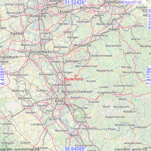
Burscheid GPS coordinates[2]
51° 5' 4.848" North, 7° 6' 50.148" East
| Map corner | latitude | longitude |
|---|---|---|
| Upper-left | 51.52426°, | 6.41081° |
| Center: | 51.08468°, | 7.11393° |
| Lower-right: | 50.64089°, | 7.81706° |
| Map W x H: | 98.2×98.2 km | = 61×61mi |
| max Lat: | 55.01917° ⇑40.4% North |
| Burscheid: | 51.08468° |
| min Lat: | ⇓59.6% South 47.40724° |
| min Long | Burscheid | max Long |
| 5.92978° | 7.11393° | 14.98853° |
| W 7.7%⇐ | ⇒92.3% E |
Elevation
Elevation of Burscheid is 191 m = 627 ft, and this is 58.1 m = 191 ft below average elevation for this country.
| Max E: |
1256 m = 4121 ft | 54.7% |
| Avg. | 249.1 m = 817 ft | |
| Burscheid | 191 m = 627 ft | |
Min E: |
-5 m = -16 ft | 45.3% |
See also: Germany elevation on elevation.city.
Geographical zone
Burscheid is located in North temperate zone (between Tropic of Cancer and the Arctic Circle). Distance of this North polar circle is 1721.1 km =1069.4 mi to North.| Distance of | km | miles | from Burscheid |
|---|---|---|---|
| North Pole | 4327 | 2688.7 | to North |
| Arctic Circle | 1721.1 | 1069.4 | to North |
| Tropic Cancer | 3074.2 | 1910.2 | to South |
| Equator | 5680.1 | 3529.4 | to South |


Nearby cities:
15 places around Burscheid: (largest is in red/bold)
• Bergisch Gladbach
11.1 km =6.9 mi,  173°
173°
• Buchheim
16.2 km =10.1 mi,  203°
203°
• Haan
14 km =8.7 mi,  329°
329°
• Hilden
15.8 km =9.8 mi,  306°
306°
• Kürten
11.3 km =7 mi,  109°
109°
• Langenfeld
11.9 km =7.4 mi,  282°
282°
• Leichlingen
7.1 km =4.4 mi,  289°
289°
• Leverkusen
10.9 km =6.8 mi,  236°
236°
• Monheim am Rhein
15.5 km =9.6 mi,  272°
272°
• Mülheim
15.2 km =9.4 mi,  210°
210°
• Odenthal
5.7 km =3.5 mi,  178°
178°
• Opladen
7.9 km =4.9 mi,  256°
256°
• Remscheid
11.9 km =7.4 mi,  27°
27°
• Solingen
10.1 km =6.3 mi,  348°
348°
• Wermelskirchen
9.4 km =5.8 mi,  49°
49°
Sources, notices
• [Note1] Compared only with cities in Germany existing in our database
• [Src1] Map data: © OpenStreetMap contributors (CC-BY-SA)
• [Src2] Other city data from geonames.org with taken over terms of usage.
• [Src3] Geographical zone / Annual Mean Temperature by Robert A. Rohde @ Wikipedia
