Oelde geodata
Oelde (North Rhine-Westphalia) is a populated place; located in Germany in Europe/Berlin (GMT+2) time zone. With population of 29,297 people, there are 481 cities with bigger population in this country. Compared to other cities in Germany, 70.2% of cities are located further ↓South; 74.8% of cities are located further →East and 70.2% of cities have higher elevation than Oelde. Note1
Administrative division(s):
- Level 1: North Rhine-Westphalia
- Level 2: Regierungsbezirk Münster
- Level 3: Kreis Warendorf
- Level 4: Oelde


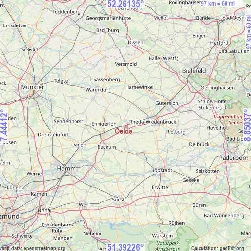
Oelde GPS coordinates[2]
51° 49' 44.04" North, 8° 8' 50.064" East
| Map corner | latitude | longitude |
|---|---|---|
| Upper-left | 52.26135°, | 7.44412° |
| Center: | 51.8289°, | 8.14724° |
| Lower-right: | 51.39226°, | 8.85037° |
| Map W x H: | 96.6×96.6 km | = 60×60mi |
| max Lat: | 55.01917° ⇑29.8% North |
| Oelde: | 51.8289° |
| min Lat: | ⇓70.2% South 47.40724° |
| min Long | Oelde | max Long |
| 5.92978° | 8.14724° | 14.98853° |
| W 25.2%⇐ | ⇒74.8% E |
Elevation
Elevation of Oelde is 90 m = 295 ft, and this is 159.1 m = 522 ft below average elevation for this country.
| Max E: |
1256 m = 4121 ft | 70.2% |
| Avg. | 249.1 m = 817 ft | |
| Oelde | 90 m = 295 ft | |
Min E: |
-5 m = -16 ft | 29.8% |
See also: Germany elevation on elevation.city.
Geographical zone
Oelde is located in North temperate zone (between Tropic of Cancer and the Arctic Circle). Distance of this North polar circle is 1638.3 km =1018 mi to North.| Distance of | km | miles | from Oelde |
|---|---|---|---|
| North Pole | 4244.2 | 2637.2 | to North |
| Arctic Circle | 1638.3 | 1018 | to North |
| Tropic Cancer | 3156.9 | 1961.6 | to South |
| Equator | 5762.8 | 3580.8 | to South |


Nearby cities:
15 places around Oelde: (largest is in red/bold)
• Ahlen
19.2 km =11.9 mi,  247°
247°
• Beckum
10.9 km =6.8 mi,  221°
221°
• Beelen
11.4 km =7.1 mi,  347°
347°
• Ennigerloh
8.1 km =5 mi,  277°
277°
• Everswinkel
23.3 km =14.5 mi,  297°
297°
• Gütersloh
18.1 km =11.2 mi,  61°
61°
• Harsewinkel
15.8 km =9.8 mi,  20°
20°
• Langenberg
13.3 km =8.3 mi,  118°
118°
• Lippstadt
22 km =13.7 mi,  141°
141°
• Rheda-Wiedenbrück
10.8 km =6.7 mi,  77°
77°
• Rietberg
19.4 km =12.1 mi,  96°
96°
• Sassenberg
19.6 km =12.2 mi,  338°
338°
• Sendenhorst
21.9 km =13.6 mi,  274°
274°
• Wadersloh
12.8 km =8 mi,  146°
146°
• Warendorf
17.5 km =10.9 mi,  321°
321°
Sources, notices
• [Note1] Compared only with cities in Germany existing in our database
• [Src1] Map data: © OpenStreetMap contributors (CC-BY-SA)
• [Src2] Other city data from geonames.org with taken over terms of usage.
• [Src3] Geographical zone / Annual Mean Temperature by Robert A. Rohde @ Wikipedia
