Beelen geodata
Beelen (North Rhine-Westphalia) is a seat of a fourth-order administrative division; located in Germany in Europe/Berlin (GMT+2) time zone. With population of 6,344 people, there are 2351 cities with bigger population in this country. Compared to other cities in Germany, 71.4% of cities are located further ↓South; 75.3% of cities are located further →East and 75.8% of cities have higher elevation than Beelen. Note1
Administrative division(s):
- Level 1: North Rhine-Westphalia
- Level 2: Regierungsbezirk Münster
- Level 3: Kreis Warendorf
- Level 4: Beelen


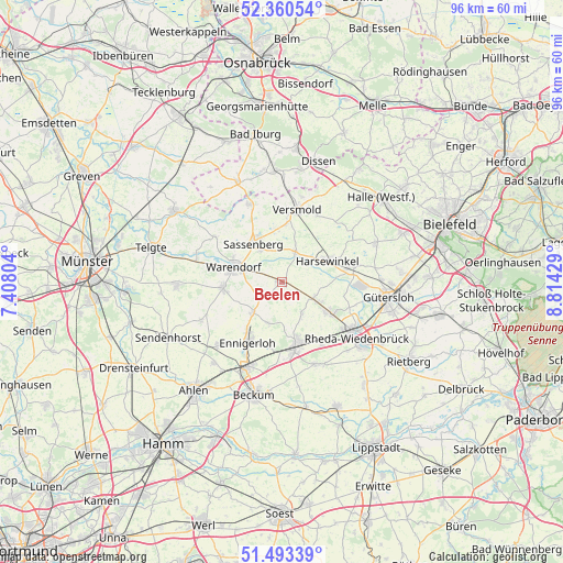
Beelen GPS coordinates[2]
51° 55' 44.616" North, 8° 6' 40.212" East
| Map corner | latitude | longitude |
|---|---|---|
| Upper-left | 52.36054°, | 7.40804° |
| Center: | 51.92906°, | 8.11117° |
| Lower-right: | 51.49339°, | 8.81429° |
| Map W x H: | 96.4×96.4 km | = 59.9×59.9mi |
| max Lat: | 55.01917° ⇑28.6% North |
| Beelen: | 51.92906° |
| min Lat: | ⇓71.4% South 47.40724° |
| min Long | Beelen | max Long |
| 5.92978° | 8.11117° | 14.98853° |
| W 24.7%⇐ | ⇒75.3% E |
Elevation
Elevation of Beelen is 60 m = 197 ft, and this is 189.1 m = 620 ft below average elevation for this country.
| Max E: |
1256 m = 4121 ft | 75.8% |
| Avg. | 249.1 m = 817 ft | |
| Beelen | 60 m = 197 ft | |
Min E: |
-5 m = -16 ft | 24.2% |
See also: Germany elevation on elevation.city.
Geographical zone
Beelen is located in North temperate zone (between Tropic of Cancer and the Arctic Circle). Distance of this North polar circle is 1627.2 km =1011.1 mi to North.| Distance of | km | miles | from Beelen |
|---|---|---|---|
| North Pole | 4233.1 | 2630.3 | to North |
| Arctic Circle | 1627.2 | 1011.1 | to North |
| Tropic Cancer | 3168.1 | 1968.6 | to South |
| Equator | 5774 | 3587.8 | to South |


Nearby cities:
15 places around Beelen: (largest is in red/bold)
• Bad Laer
19.1 km =11.9 mi,  354°
354°
• Bad Rothenfelde
21.2 km =13.2 mi,  10°
10°
• Beckum
19.9 km =12.4 mi,  194°
194°
• Ennigerloh
11.5 km =7.1 mi,  208°
208°
• Everswinkel
18.1 km =11.2 mi,  268°
268°
• Glandorf
18.9 km =11.7 mi,  336°
336°
• Gütersloh
18.5 km =11.5 mi,  97°
97°
• Harsewinkel
8.8 km =5.5 mi,  65°
65°
• Oelde
11.4 km =7.1 mi,  167°
167°
• Rheda-Wiedenbrück
15.7 km =9.8 mi,  124°
124°
• Sassenberg
8.5 km =5.3 mi,  325°
325°
• Sendenhorst
21.5 km =13.4 mi,  243°
243°
• Steinhagen
21.3 km =13.2 mi, 68°
• Versmold
12.7 km =7.9 mi, 12°
• Warendorf
8.8 km =5.5 mi,  286°
286°
Sources, notices
• [Note1] Compared only with cities in Germany existing in our database
• [Src1] Map data: © OpenStreetMap contributors (CC-BY-SA)
• [Src2] Other city data from geonames.org with taken over terms of usage.
• [Src3] Geographical zone / Annual Mean Temperature by Robert A. Rohde @ Wikipedia
