Beckum geodata
Beckum (North Rhine-Westphalia) is a populated place; located in Germany in Europe/Berlin (GMT+2) time zone. With population of 37,814 people, there are 350 cities with bigger population in this country. Compared to other cities in Germany, 69.4% of cities are located further ↓South; 76.4% of cities are located further →East and 65.7% of cities have higher elevation than Beckum. Note1
Administrative division(s):
- Level 1: North Rhine-Westphalia
- Level 2: Regierungsbezirk Münster
- Level 3: Kreis Warendorf
- Level 4: Beckum


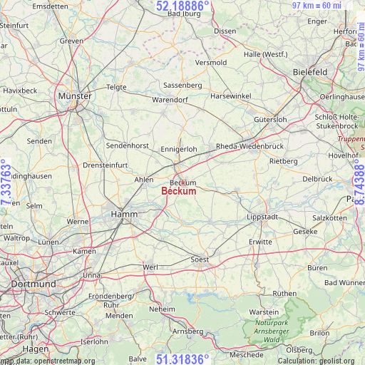
Beckum GPS coordinates[2]
51° 45' 20.556" North, 8° 2' 26.7" East
| Map corner | latitude | longitude |
|---|---|---|
| Upper-left | 52.18886°, | 7.33763° |
| Center: | 51.75571°, | 8.04075° |
| Lower-right: | 51.31836°, | 8.74388° |
| Map W x H: | 96.8×96.8 km | = 60.1×60.1mi |
| max Lat: | 55.01917° ⇑30.6% North |
| Beckum: | 51.75571° |
| min Lat: | ⇓69.4% South 47.40724° |
| min Long | Beckum | max Long |
| 5.92978° | 8.04075° | 14.98853° |
| W 23.6%⇐ | ⇒76.4% E |
Elevation
Elevation of Beckum is 116 m = 381 ft, and this is 133.1 m = 437 ft below average elevation for this country.
| Max E: |
1256 m = 4121 ft | 65.7% |
| Avg. | 249.1 m = 817 ft | |
| Beckum | 116 m = 381 ft | |
Min E: |
-5 m = -16 ft | 34.3% |
See also: Germany elevation on elevation.city.
Geographical zone
Beckum is located in North temperate zone (between Tropic of Cancer and the Arctic Circle). Distance of this North polar circle is 1646.5 km =1023.1 mi to North.| Distance of | km | miles | from Beckum |
|---|---|---|---|
| North Pole | 4252.4 | 2642.3 | to North |
| Arctic Circle | 1646.5 | 1023.1 | to North |
| Tropic Cancer | 3148.8 | 1956.6 | to South |
| Equator | 5754.7 | 3575.8 | to South |


Nearby cities:
15 places around Beckum: (largest is in red/bold)
• Ahlen
10.5 km =6.5 mi,  274°
274°
• Bad Sassendorf
21 km =13 mi,  155°
155°
• Beelen
19.9 km =12.4 mi,  14°
14°
• Drensteinfurt
21.3 km =13.2 mi,  281°
281°
• Ennigerloh
9.2 km =5.7 mi,  355°
355°
• Hamm
17.3 km =10.7 mi,  241°
241°
• Langenberg
19.2 km =11.9 mi,  84°
84°
• Lippstadt
22.8 km =14.2 mi,  113°
113°
• Oelde
10.9 km =6.8 mi,  41°
41°
• Rheda-Wiedenbrück
20.7 km =12.9 mi,  59°
59°
• Sendenhorst
17.4 km =10.8 mi,  303°
303°
• Soest
20.5 km =12.7 mi,  167°
167°
• Wadersloh
14.6 km =9.1 mi,  99°
99°
• Warendorf
22 km =13.7 mi,  350°
350°
• Welver
16.3 km =10.1 mi,  198°
198°
Sources, notices
• [Note1] Compared only with cities in Germany existing in our database
• [Src1] Map data: © OpenStreetMap contributors (CC-BY-SA)
• [Src2] Other city data from geonames.org with taken over terms of usage.
• [Src3] Geographical zone / Annual Mean Temperature by Robert A. Rohde @ Wikipedia
