Freren geodata
Freren (Lower Saxony) is a populated place; located in Germany in Europe/Berlin (GMT+2) time zone. With population of 5,150 people, there are 2770 cities with bigger population in this country. Compared to other cities in Germany, 77.3% of cities are located further ↓South; 86.2% of cities are located further →East and 82.3% of cities have higher elevation than Freren. Note1


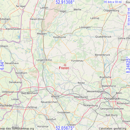
Freren GPS coordinates[2]
52° 29' 13.2" North, 7° 32' 35.268" East
| Map corner | latitude | longitude |
|---|---|---|
| Upper-left | 52.91308°, | 6.84° |
| Center: | 52.487°, | 7.54313° |
| Lower-right: | 52.05675°, | 8.24625° |
| Map W x H: | 95.2×95.2 km | = 59.2×59.2mi |
| max Lat: | 55.01917° ⇑22.7% North |
| Freren: | 52.487° |
| min Lat: | ⇓77.3% South 47.40724° |
| min Long | Freren | max Long |
| 5.92978° | 7.54313° | 14.98853° |
| W 13.8%⇐ | ⇒86.2% E |
Elevation
Elevation of Freren is 41 m = 135 ft, and this is 208.1 m = 683 ft below average elevation for this country.
| Max E: |
1256 m = 4121 ft | 82.3% |
| Avg. | 249.1 m = 817 ft | |
| Freren | 41 m = 135 ft | |
Min E: |
-5 m = -16 ft | 17.7% |
See also: Germany elevation on elevation.city.
Geographical zone
Freren is located in North temperate zone (between Tropic of Cancer and the Arctic Circle). Distance of this North polar circle is 1565.2 km =972.6 mi to North.| Distance of | km | miles | from Freren |
|---|---|---|---|
| North Pole | 4171.1 | 2591.8 | to North |
| Arctic Circle | 1565.2 | 972.6 | to North |
| Tropic Cancer | 3230.1 | 2007.1 | to South |
| Equator | 5836 | 3626.3 | to South |


Nearby cities:
15 places around Freren: (largest is in red/bold)
• Andervenne Oberdorf
4.3 km =2.7 mi,  39°
39°
• Beesten
6.6 km =4.1 mi,  206°
206°
• Fürstenau
9.6 km =6 mi,  69°
69°
• Gersten
10.9 km =6.8 mi,  350°
350°
• Handrup
8.9 km =5.5 mi,  14°
14°
• Hopsten
12.4 km =7.7 mi,  161°
161°
• Langen
7.8 km =4.8 mi,  318°
318°
• Lengerich
7.5 km =4.7 mi, 354°
• Lünne
10.2 km =6.3 mi,  231°
231°
• Messingen
5.7 km =3.5 mi,  246°
246°
• Schapen
9.8 km =6.1 mi,  170°
170°
• Spelle
14.3 km =8.9 mi,  201°
201°
• Thuine
4.3 km =2.7 mi,  289°
289°
• Voltlage
15.2 km =9.4 mi,  113°
113°
• Wettrup
11.9 km =7.4 mi,  18°
18°
Sources, notices
• [Note1] Compared only with cities in Germany existing in our database
• [Src1] Map data: © OpenStreetMap contributors (CC-BY-SA)
• [Src2] Other city data from geonames.org with taken over terms of usage.
• [Src3] Geographical zone / Annual Mean Temperature by Robert A. Rohde @ Wikipedia
