Bürstadt geodata
Bürstadt (Hesse) is a populated place; located in Germany in Europe/Berlin (GMT+2) time zone. With population of 15,348 people, there are 1039 cities with bigger population in this country. Compared to other cities in Germany, 72.7% of cities are located further ↑North; 71.5% of cities are located further →East and 69.4% of cities have higher elevation than Bürstadt. Note1
Administrative division(s):
- Level 1: Hesse
- Level 2: Regierungsbezirk Darmstadt
- Level 3: Landkreis Bergstraße
- Level 4: Bürstadt


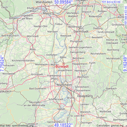
Bürstadt GPS coordinates[2]
49° 38' 33.576" North, 8° 27' 33.696" East
| Map corner | latitude | longitude |
|---|---|---|
| Upper-left | 50.09584°, | 7.75624° |
| Center: | 49.64266°, | 8.45936° |
| Lower-right: | 49.18522°, | 9.16249° |
| Map W x H: | 101.3×101.3 km | = 62.9×62.9mi |
| max Lat: | 55.01917° ⇑72.7% North |
| Bürstadt: | 49.64266° |
| min Lat: | ⇓27.3% South 47.40724° |
| min Long | Bürstadt | max Long |
| 5.92978° | 8.45936° | 14.98853° |
| W 28.5%⇐ | ⇒71.5% E |
Elevation
Elevation of Bürstadt is 95 m = 312 ft, and this is 154.1 m = 506 ft below average elevation for this country.
| Max E: |
1256 m = 4121 ft | 69.4% |
| Avg. | 249.1 m = 817 ft | |
| Bürstadt | 95 m = 312 ft | |
Min E: |
-5 m = -16 ft | 30.6% |
See also: Germany elevation on elevation.city.
Geographical zone
Bürstadt is located in North temperate zone (between Tropic of Cancer and the Arctic Circle). Distance of this North polar circle is 1881.4 km =1169 mi to North.| Distance of | km | miles | from Bürstadt |
|---|---|---|---|
| North Pole | 4487.3 | 2788.3 | to North |
| Arctic Circle | 1881.4 | 1169 | to North |
| Tropic Cancer | 2913.8 | 1810.6 | to South |
| Equator | 5519.7 | 3429.8 | to South |


Nearby cities:
15 places around Bürstadt: (largest is in red/bold)
• Beindersheim
13.6 km =8.5 mi,  227°
227°
• Bensheim
12.3 km =7.6 mi,  68°
68°
• Biblis
5.4 km =3.4 mi,  359°
359°
• Bobenheim-Roxheim
9.5 km =5.9 mi, 230°
• Eich
12.7 km =7.9 mi,  339°
339°
• Einhausen
7.4 km =4.6 mi,  59°
59°
• Gernsheim
12.5 km =7.8 mi,  9°
9°
• Groß-Rohrheim
8.9 km =5.5 mi, 10°
• Großniedesheim
13 km =8.1 mi, 234°
• Heppenheim an der Bergstrasse
12.4 km =7.7 mi,  90°
90°
• Kleinniedesheim
11.7 km =7.3 mi,  237°
237°
• Lampertheim
5.1 km =3.2 mi,  169°
169°
• Lorsch
7.8 km =4.8 mi,  83°
83°
• Osthofen
11.9 km =7.4 mi,  304°
304°
• Worms
7.3 km =4.5 mi,  261°
261°
Sources, notices
• [Note1] Compared only with cities in Germany existing in our database
• [Src1] Map data: © OpenStreetMap contributors (CC-BY-SA)
• [Src2] Other city data from geonames.org with taken over terms of usage.
• [Src3] Geographical zone / Annual Mean Temperature by Robert A. Rohde @ Wikipedia
