Kurort Oberwiesenthal geodata
Kurort Oberwiesenthal (Saxony) is a populated place; located in Germany in Europe/Berlin (GMT+2) time zone. With population of 2,592 people, there are 4338 cities with bigger population in this country. Compared to other cities in Germany, 54.2% of cities are located further ↑North; 92% of cities are located further ←West and 99.9% of cities have lower elevation than Kurort Oberwiesenthal. Note1
Administrative division(s):
- Level 1: Saxony
- Level 3: Erzgebirgskreis
- Level 4: Oberwiesenthal, Kurort


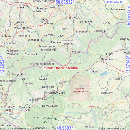
Kurort Oberwiesenthal GPS coordinates[2]
50° 25' 9.948" North, 12° 58' 6.096" East
| Map corner | latitude | longitude |
|---|---|---|
| Upper-left | 50.86532°, | 12.26524° |
| Center: | 50.41943°, | 12.96836° |
| Lower-right: | 49.9693°, | 13.67149° |
| Map W x H: | 99.6×99.6 km | = 61.9×61.9mi |
| max Lat: | 55.01917° ⇑54.2% North |
| Kurort Oberwiesenthal: | 50.41943° |
| min Lat: | ⇓45.8% South 47.40724° |
| min Long | Kurort Oberwies | max Long |
| 5.92978° | 12.96836° | 14.98853° |
| W 92%⇐ | ⇒8% E |
Elevation
Elevation of Kurort Oberwiesenthal is 926 m = 3038 ft, and this is 676.9 m = 2221 ft above average elevation for this country.
| Max E: |
1256 m = 4121 ft | 0.099999999999994% |
| Kurort Oberwiesenthal | 926 m 3038 ft | |
| Avg. | 249.1 m = 817 ft | |
Min E: |
-5 m = -16 ft | 99.9% |
See also: Germany elevation on elevation.city.
Geographical zone
Kurort Oberwiesenthal is located in North temperate zone (between Tropic of Cancer and the Arctic Circle). Distance of this North polar circle is 1795.1 km =1115.4 mi to North.| Distance of | km | miles | from Kurort Oberwiesenthal |
|---|---|---|---|
| North Pole | 4400.9 | 2734.6 | to North |
| Arctic Circle | 1795.1 | 1115.4 | to North |
| Tropic Cancer | 3000.2 | 1864.2 | to South |
| Equator | 5606.1 | 3483.5 | to South |


Nearby cities:
15 places around Kurort Oberwiesenthal: (largest is in red/bold)
• Annaberg-Buchholz
18 km =11.2 mi,  8°
8°
• Breitenbrunn
15.6 km =9.7 mi,  293°
293°
• Bärenstein
10.1 km =6.3 mi,  27°
27°
• Crottendorf
10.9 km =6.8 mi,  353°
353°
• Elterlein
18.9 km =11.7 mi,  337°
337°
• Johanngeorgenstadt
18.3 km =11.4 mi,  274°
274°
• Jöhstadt
13.7 km =8.5 mi,  40°
40°
• Königswalde
15.6 km =9.7 mi,  21°
21°
• Markersbach
15 km =9.3 mi,  329°
329°
• Pöhla
14.7 km =9.1 mi,  314°
314°
• Raschau
15.7 km =9.8 mi,  322°
322°
• Rittersgrün
14.1 km =8.8 mi,  298°
298°
• Scheibenberg
14 km =8.7 mi, 343°
• Schlettau
15.5 km =9.6 mi,  355°
355°
• Schwarzenberg
18.5 km =11.5 mi, 315°
Sources, notices
• [Note1] Compared only with cities in Germany existing in our database
• [Src1] Map data: © OpenStreetMap contributors (CC-BY-SA)
• [Src2] Other city data from geonames.org with taken over terms of usage.
• [Src3] Geographical zone / Annual Mean Temperature by Robert A. Rohde @ Wikipedia
