Königswalde geodata
Königswalde (Saxony) is a seat of a fourth-order administrative division; located in Germany in Europe/Berlin (GMT+2) time zone. With population of 2,477 people, there are 4469 cities with bigger population in this country. Compared to other cities in Germany, 51.7% of cities are located further ↑North; 92.6% of cities are located further ←West and 93.2% of cities have lower elevation than Königswalde. Note1


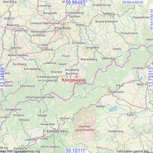
Königswalde GPS coordinates[2]
50° 33' 0" North, 13° 3' 0" East
| Map corner | latitude | longitude |
|---|---|---|
| Upper-left | 50.99465°, | 12.34688° |
| Center: | 50.55°, | 13.05° |
| Lower-right: | 50.10111°, | 13.75313° |
| Map W x H: | 99.4×99.4 km | = 61.8×61.8mi |
| max Lat: | 55.01917° ⇑51.7% North |
| Königswalde: | 50.55° |
| min Lat: | ⇓48.3% South 47.40724° |
| min Long | Königswalde | max Long |
| 5.92978° | 13.05° | 14.98853° |
| W 92.6%⇐ | ⇒7.4% E |
Elevation
Elevation of Königswalde is 562 m = 1844 ft, and this is 312.9 m = 1027 ft above average elevation for this country.
| Max E: |
1256 m = 4121 ft | 6.8% |
| Königswalde | 562 m 1844 ft | |
| Avg. | 249.1 m = 817 ft | |
Min E: |
-5 m = -16 ft | 93.2% |
See also: Germany elevation on elevation.city.
Geographical zone
Königswalde is located in North temperate zone (between Tropic of Cancer and the Arctic Circle). Distance of this North polar circle is 1780.5 km =1106.4 mi to North.| Distance of | km | miles | from Königswalde |
|---|---|---|---|
| North Pole | 4386.4 | 2725.6 | to North |
| Arctic Circle | 1780.5 | 1106.4 | to North |
| Tropic Cancer | 3014.7 | 1873.2 | to South |
| Equator | 5620.6 | 3492.5 | to South |


Nearby cities:
15 places around Königswalde: (largest is in red/bold)
• Annaberg-Buchholz
4.5 km =2.8 mi,  316°
316°
• Bärenstein
5.7 km =3.5 mi,  191°
191°
• Crottendorf
8 km =5 mi,  242°
242°
• Ehrenfriedersdorf
12.4 km =7.7 mi,  332°
332°
• Elterlein
13.2 km =8.2 mi,  282°
282°
• Geyer
12.5 km =7.8 mi,  312°
312°
• Großrückerswalde
10.4 km =6.5 mi,  26°
26°
• Jöhstadt
5.2 km =3.2 mi,  143°
143°
• Mildenau
4.4 km =2.7 mi,  21°
21°
• Scheibenberg
9.8 km =6.1 mi,  263°
263°
• Schlettau
6.9 km =4.3 mi, 278°
• Tannenberg
10.2 km =6.3 mi, 308°
• Thermalbad Wiesenbad
7.4 km =4.6 mi,  0°
0°
• Wiesa
7.3 km =4.5 mi,  339°
339°
• Wolkenstein
11.8 km =7.3 mi,  7°
7°
Sources, notices
• [Note1] Compared only with cities in Germany existing in our database
• [Src1] Map data: © OpenStreetMap contributors (CC-BY-SA)
• [Src2] Other city data from geonames.org with taken over terms of usage.
• [Src3] Geographical zone / Annual Mean Temperature by Robert A. Rohde @ Wikipedia
