Annaberg-Buchholz geodata
Annaberg-Buchholz (Saxony) is a seat of a third-order administrative division; located in Germany in Europe/Berlin (GMT+2) time zone. With population of 23,092 people, there are 643 cities with bigger population in this country. Compared to other cities in Germany, 51.1% of cities are located further ↑North; 92.4% of cities are located further ←West and 96% of cities have lower elevation than Annaberg-Buchholz. Note1


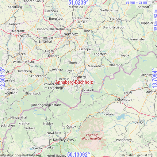
Annaberg-Buchholz GPS coordinates[2]
50° 34' 46.308" North, 13° 0' 22.572" East
| Map corner | latitude | longitude |
|---|---|---|
| Upper-left | 51.0239°, | 12.30315° |
| Center: | 50.57953°, | 13.00627° |
| Lower-right: | 50.13092°, | 13.7094° |
| Map W x H: | 99.3×99.3 km | = 61.7×61.7mi |
| max Lat: | 55.01917° ⇑51.1% North |
| Annaberg-Buchholz: | 50.57953° |
| min Lat: | ⇓48.9% South 47.40724° |
| min Long | Annaberg-Buchho | max Long |
| 5.92978° | 13.00627° | 14.98853° |
| W 92.4%⇐ | ⇒7.6% E |
Elevation
Elevation of Annaberg-Buchholz is 627 m = 2057 ft, and this is 377.9 m = 1240 ft above average elevation for this country.
| Max E: |
1256 m = 4121 ft | 4% |
| Annaberg-Buchholz | 627 m 2057 ft | |
| Avg. | 249.1 m = 817 ft | |
Min E: |
-5 m = -16 ft | 96% |
See also: Germany elevation on elevation.city.
Geographical zone
Annaberg-Buchholz is located in North temperate zone (between Tropic of Cancer and the Arctic Circle). Distance of this North polar circle is 1777.3 km =1104.4 mi to North.| Distance of | km | miles | from Annaberg-Buchholz |
|---|---|---|---|
| North Pole | 4383.1 | 2723.5 | to North |
| Arctic Circle | 1777.3 | 1104.4 | to North |
| Tropic Cancer | 3018 | 1875.3 | to South |
| Equator | 5623.9 | 3494.5 | to South |


Nearby cities:
15 places around Annaberg-Buchholz: (largest is in red/bold)
• Bärenstein
9 km =5.6 mi,  167°
167°
• Crottendorf
8 km =5 mi,  209°
209°
• Ehrenfriedersdorf
8.2 km =5.1 mi,  341°
341°
• Elterlein
9.7 km =6 mi,  268°
268°
• Geyer
8 km =5 mi,  310°
310°
• Großrückerswalde
9.8 km =6.1 mi,  52°
52°
• Jöhstadt
9.7 km =6 mi,  140°
140°
• Königswalde
4.5 km =2.8 mi, 136°
• Mildenau
4.8 km =3 mi,  80°
80°
• Scheibenberg
8 km =5 mi,  236°
236°
• Schlettau
4.4 km =2.7 mi, 238°
• Tannenberg
5.7 km =3.5 mi,  302°
302°
• Thermalbad Wiesenbad
5.2 km =3.2 mi,  36°
36°
• Wiesa
3.6 km =2.2 mi,  8°
8°
• Wolkenstein
9.6 km =6 mi,  28°
28°
Sources, notices
• [Note1] Compared only with cities in Germany existing in our database
• [Src1] Map data: © OpenStreetMap contributors (CC-BY-SA)
• [Src2] Other city data from geonames.org with taken over terms of usage.
• [Src3] Geographical zone / Annual Mean Temperature by Robert A. Rohde @ Wikipedia
