Forchtenberg geodata
Forchtenberg (Baden-Württemberg) is a populated place; located in Germany in Europe/Berlin (GMT+2) time zone. With population of 5,105 people, there are 2787 cities with bigger population in this country. Compared to other cities in Germany, 78.9% of cities are located further ↑North; 56.9% of cities are located further →East and 54% of cities have higher elevation than Forchtenberg. Note1
Administrative division(s):
- Level 1: Baden-Württemberg
- Level 2: Regierungsbezirk Stuttgart
- Level 3: Hohenlohekreis
- Level 4: Forchtenberg


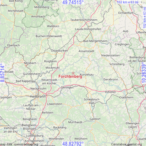
Forchtenberg GPS coordinates[2]
49° 17' 19.212" North, 9° 33' 36.936" East
| Map corner | latitude | longitude |
|---|---|---|
| Upper-left | 49.74515°, | 8.85714° |
| Center: | 49.28867°, | 9.56026° |
| Lower-right: | 48.82792°, | 10.26339° |
| Map W x H: | 102×102 km | = 63.4×63.4mi |
| max Lat: | 55.01917° ⇑78.9% North |
| Forchtenberg: | 49.28867° |
| min Lat: | ⇓21.1% South 47.40724° |
| min Long | Forchtenberg | max Long |
| 5.92978° | 9.56026° | 14.98853° |
| W 43.1%⇐ | ⇒56.9% E |
Elevation
Elevation of Forchtenberg is 197 m = 646 ft, and this is 52.1 m = 171 ft below average elevation for this country.
| Max E: |
1256 m = 4121 ft | 54% |
| Avg. | 249.1 m = 817 ft | |
| Forchtenberg | 197 m = 646 ft | |
Min E: |
-5 m = -16 ft | 46% |
See also: Germany elevation on elevation.city.
Geographical zone
Forchtenberg is located in North temperate zone (between Tropic of Cancer and the Arctic Circle). Distance of this North polar circle is 1920.8 km =1193.5 mi to North.| Distance of | km | miles | from Forchtenberg |
|---|---|---|---|
| North Pole | 4526.7 | 2812.8 | to North |
| Arctic Circle | 1920.8 | 1193.5 | to North |
| Tropic Cancer | 2874.5 | 1786.1 | to South |
| Equator | 5480.4 | 3405.4 | to South |


Nearby cities:
15 places around Forchtenberg: (largest is in red/bold)
• Dörzbach
15 km =9.3 mi,  45°
45°
• Ingelfingen
6.8 km =4.2 mi,  79°
79°
• Jagsthausen
7.1 km =4.4 mi,  290°
290°
• Krautheim
12.3 km =7.6 mi,  26°
26°
• Kupferzell
11.6 km =7.2 mi,  125°
125°
• Künzelsau
9 km =5.6 mi,  94°
94°
• Langenbrettach
12.4 km =7.7 mi,  235°
235°
• Neuenstein
9.4 km =5.8 mi,  171°
171°
• Niedernhall
4.1 km =2.5 mi, 79°
• Pfedelbach
12.9 km =8 mi,  198°
198°
• Waldenburg
12.9 km =8 mi,  153°
153°
• Weißbach
2.7 km =1.7 mi,  69°
69°
• Widdern
10.5 km =6.5 mi, 288°
• Zweiflingen
4.7 km =2.9 mi,  220°
220°
• Öhringen
10.7 km =6.6 mi, 201°
Sources, notices
• [Note1] Compared only with cities in Germany existing in our database
• [Src1] Map data: © OpenStreetMap contributors (CC-BY-SA)
• [Src2] Other city data from geonames.org with taken over terms of usage.
• [Src3] Geographical zone / Annual Mean Temperature by Robert A. Rohde @ Wikipedia
