Öhringen geodata
Öhringen (Baden-Württemberg) is a populated place; located in Germany in Europe/Berlin (GMT+2) time zone. With population of 22,765 people, there are 657 cities with bigger population in this country. Compared to other cities in Germany, 80.3% of cities are located further ↑North; 57.7% of cities are located further →East and 50.3% of cities have lower elevation than Öhringen. Note1
Administrative division(s):
- Level 1: Baden-Württemberg
- Level 2: Regierungsbezirk Stuttgart
- Level 3: Hohenlohekreis
- Level 4: Öhringen


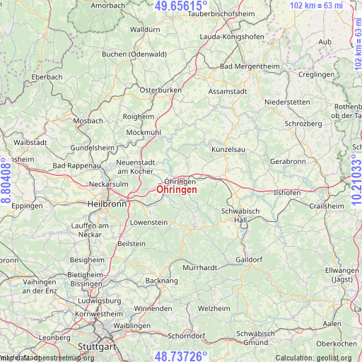
Öhringen GPS coordinates[2]
49° 11' 55.824" North, 9° 30' 25.92" East
| Map corner | latitude | longitude |
|---|---|---|
| Upper-left | 49.65615°, | 8.80408° |
| Center: | 49.19884°, | 9.5072° |
| Lower-right: | 48.73726°, | 10.21033° |
| Map W x H: | 102.2×102.2 km | = 63.5×63.5mi |
| max Lat: | 55.01917° ⇑80.3% North |
| Öhringen: | 49.19884° |
| min Lat: | ⇓19.7% South 47.40724° |
| min Long | Öhringen | max Long |
| 5.92978° | 9.5072° | 14.98853° |
| W 42.3%⇐ | ⇒57.7% E |
Elevation
Elevation of Öhringen is 228 m = 748 ft, and this is 21.1 m = 69 ft below average elevation for this country.
| Max E: |
1256 m = 4121 ft | 49.7% |
| Avg. | 249.1 m = 817 ft | |
| Öhringen | 228 m = 748 ft | |
Min E: |
-5 m = -16 ft | 50.3% |
See also: Germany elevation on elevation.city.
Geographical zone
Öhringen is located in North temperate zone (between Tropic of Cancer and the Arctic Circle). Distance of this North polar circle is 1930.8 km =1199.7 mi to North.| Distance of | km | miles | from Öhringen |
|---|---|---|---|
| North Pole | 4536.7 | 2819 | to North |
| Arctic Circle | 1930.8 | 1199.7 | to North |
| Tropic Cancer | 2864.5 | 1779.9 | to South |
| Equator | 5470.4 | 3399.1 | to South |


Nearby cities:
15 places around Öhringen: (largest is in red/bold)
• Bretzfeld
5.4 km =3.4 mi,  246°
246°
• Eberstadt
13.7 km =8.5 mi,  261°
261°
• Forchtenberg
10.7 km =6.6 mi,  21°
21°
• Jagsthausen
12.7 km =7.9 mi,  347°
347°
• Kupferzell
13.7 km =8.5 mi,  76°
76°
• Langenbrettach
7.1 km =4.4 mi,  295°
295°
• Mainhardt
14.1 km =8.8 mi,  165°
165°
• Neuenstadt am Kocher
13.3 km =8.3 mi,  287°
287°
• Neuenstein
5.3 km =3.3 mi, 82°
• Niedernhall
13.3 km =8.3 mi,  36°
36°
• Pfedelbach
2.3 km =1.4 mi,  183°
183°
• Waldenburg
9.8 km =6.1 mi,  99°
99°
• Weißbach
12.7 km =7.9 mi,  30°
30°
• Wüstenrot
13.6 km =8.5 mi,  194°
194°
• Zweiflingen
6.4 km =4 mi,  7°
7°
Sources, notices
• [Note1] Compared only with cities in Germany existing in our database
• [Src1] Map data: © OpenStreetMap contributors (CC-BY-SA)
• [Src2] Other city data from geonames.org with taken over terms of usage.
• [Src3] Geographical zone / Annual Mean Temperature by Robert A. Rohde @ Wikipedia
