Kreuzau geodata
Kreuzau (North Rhine-Westphalia) is a seat of a fourth-order administrative division; located in Germany in Europe/Berlin (GMT+2) time zone. With population of 18,400 people, there are 856 cities with bigger population in this country. Compared to other cities in Germany, 53.2% of cities are located further ↓South; 97.8% of cities are located further →East and 60.6% of cities have higher elevation than Kreuzau. Note1
Administrative division(s):
- Level 1: North Rhine-Westphalia
- Level 2: Regierungsbezirk Köln
- Level 3: Kreis Düren
- Level 4: Kreuzau


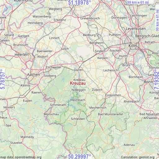
Kreuzau GPS coordinates[2]
50° 44' 49.164" North, 6° 29' 26.484" East
| Map corner | latitude | longitude |
|---|---|---|
| Upper-left | 51.18978°, | 5.78757° |
| Center: | 50.74699°, | 6.49069° |
| Lower-right: | 50.29997°, | 7.19382° |
| Map W x H: | 98.9×98.9 km | = 61.5×61.5mi |
| max Lat: | 55.01917° ⇑46.8% North |
| Kreuzau: | 50.74699° |
| min Lat: | ⇓53.2% South 47.40724° |
| min Long | Kreuzau | max Long |
| 5.92978° | 6.49069° | 14.98853° |
| W 2.2%⇐ | ⇒97.8% E |
Elevation
Elevation of Kreuzau is 148 m = 486 ft, and this is 101.1 m = 332 ft below average elevation for this country.
| Max E: |
1256 m = 4121 ft | 60.6% |
| Avg. | 249.1 m = 817 ft | |
| Kreuzau | 148 m = 486 ft | |
Min E: |
-5 m = -16 ft | 39.4% |
See also: Germany elevation on elevation.city.
Geographical zone
Kreuzau is located in North temperate zone (between Tropic of Cancer and the Arctic Circle). Distance of this North polar circle is 1758.6 km =1092.7 mi to North.| Distance of | km | miles | from Kreuzau |
|---|---|---|---|
| North Pole | 4364.5 | 2712 | to North |
| Arctic Circle | 1758.6 | 1092.7 | to North |
| Tropic Cancer | 3036.6 | 1886.9 | to South |
| Equator | 5642.5 | 3506.1 | to South |


Nearby cities:
15 places around Kreuzau: (largest is in red/bold)
• Breinigerberg
17.7 km =11 mi,  266°
266°
• Düren
6.4 km =4 mi,  1°
1°
• Eschweiler
17.3 km =10.7 mi,  297°
297°
• Heimbach
12.3 km =7.6 mi,  187°
187°
• Hürtgenwald
9.4 km =5.8 mi,  248°
248°
• Inden
14.1 km =8.8 mi,  319°
319°
• Langerwehe
12.6 km =7.8 mi,  308°
308°
• Merzenich
9.2 km =5.7 mi,  15°
15°
• Nideggen
6.1 km =3.8 mi,  184°
184°
• Niederzier
15.3 km =9.5 mi,  353°
353°
• Nörvenich
12.4 km =7.7 mi,  57°
57°
• Rurberg
16.7 km =10.4 mi,  207°
207°
• Stolberg
18.9 km =11.7 mi,  279°
279°
• Vettweiß
7.8 km =4.8 mi,  101°
101°
• Zulpich
12.9 km =8 mi,  116°
116°
Sources, notices
• [Note1] Compared only with cities in Germany existing in our database
• [Src1] Map data: © OpenStreetMap contributors (CC-BY-SA)
• [Src2] Other city data from geonames.org with taken over terms of usage.
• [Src3] Geographical zone / Annual Mean Temperature by Robert A. Rohde @ Wikipedia
