Nörvenich geodata
Nörvenich (North Rhine-Westphalia) is a seat of a fourth-order administrative division; located in Germany in Europe/Berlin (GMT+2) time zone. With population of 11,481 people, there are 1435 cities with bigger population in this country. Compared to other cities in Germany, 54.3% of cities are located further ↓South; 96.7% of cities are located further →East and 65.2% of cities have higher elevation than Nörvenich. Note1
Administrative division(s):
- Level 1: North Rhine-Westphalia
- Level 2: Regierungsbezirk Köln
- Level 3: Kreis Düren
- Level 4: Nörvenich


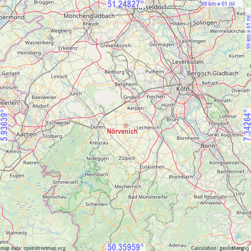
Nörvenich GPS coordinates[2]
50° 48' 21.744" North, 6° 38' 22.272" East
| Map corner | latitude | longitude |
|---|---|---|
| Upper-left | 51.24827°, | 5.93639° |
| Center: | 50.80604°, | 6.63952° |
| Lower-right: | 50.35959°, | 7.34264° |
| Map W x H: | 98.8×98.8 km | = 61.4×61.4mi |
| max Lat: | 55.01917° ⇑45.7% North |
| Nörvenich: | 50.80604° |
| min Lat: | ⇓54.3% South 47.40724° |
| min Long | Nörvenich | max Long |
| 5.92978° | 6.63952° | 14.98853° |
| W 3.3%⇐ | ⇒96.7% E |
Elevation
Elevation of Nörvenich is 119 m = 390 ft, and this is 130.1 m = 427 ft below average elevation for this country.
| Max E: |
1256 m = 4121 ft | 65.2% |
| Avg. | 249.1 m = 817 ft | |
| Nörvenich | 119 m = 390 ft | |
Min E: |
-5 m = -16 ft | 34.8% |
See also: Germany elevation on elevation.city.
Geographical zone
Nörvenich is located in North temperate zone (between Tropic of Cancer and the Arctic Circle). Distance of this North polar circle is 1752.1 km =1088.7 mi to North.| Distance of | km | miles | from Nörvenich |
|---|---|---|---|
| North Pole | 4358 | 2707.9 | to North |
| Arctic Circle | 1752.1 | 1088.7 | to North |
| Tropic Cancer | 3043.2 | 1891 | to South |
| Equator | 5649.1 | 3510.2 | to South |


Nearby cities:
15 places around Nörvenich: (largest is in red/bold)
• Bergheim
16.6 km =10.3 mi,  0°
0°
• Düren
10.3 km =6.4 mi,  268°
268°
• Elsdorf
15.4 km =9.6 mi,  341°
341°
• Erftstadt
10.9 km =6.8 mi,  84°
84°
• Frechen
17.1 km =10.6 mi,  44°
44°
• Hürth
17.6 km =10.9 mi,  65°
65°
• Kerpen
8.2 km =5.1 mi,  29°
29°
• Kreuzau
12.4 km =7.7 mi,  237°
237°
• Merzenich
8.4 km =5.2 mi,  286°
286°
• Nideggen
16.7 km =10.4 mi,  220°
220°
• Niederzier
14.9 km =9.3 mi,  305°
305°
• Türnich
10 km =6.2 mi,  54°
54°
• Vettweiß
8.5 km =5.3 mi,  198°
198°
• Weilerswist
15.7 km =9.8 mi,  112°
112°
• Zulpich
12.4 km =7.7 mi,  175°
175°
Sources, notices
• [Note1] Compared only with cities in Germany existing in our database
• [Src1] Map data: © OpenStreetMap contributors (CC-BY-SA)
• [Src2] Other city data from geonames.org with taken over terms of usage.
• [Src3] Geographical zone / Annual Mean Temperature by Robert A. Rohde @ Wikipedia
