Heimbach geodata
Heimbach (North Rhine-Westphalia) is a populated place; located in Germany in Europe/Berlin (GMT+2) time zone. With population of 4,658 people, there are 2959 cities with bigger population in this country. Compared to other cities in Germany, 50.5% of cities are located further ↓South; 98% of cities are located further →East and 50.2% of cities have higher elevation than Heimbach. Note1
Administrative division(s):
- Level 1: North Rhine-Westphalia
- Level 2: Regierungsbezirk Köln
- Level 3: Kreis Düren
- Level 4: Heimbach


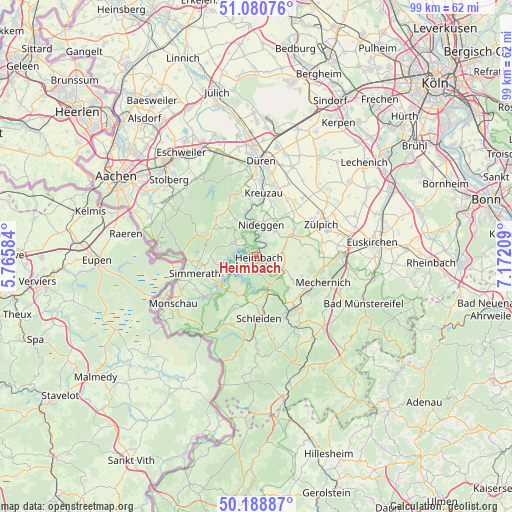
Heimbach GPS coordinates[2]
50° 38' 12.948" North, 6° 28' 8.256" East
| Map corner | latitude | longitude |
|---|---|---|
| Upper-left | 51.08076°, | 5.76584° |
| Center: | 50.63693°, | 6.46896° |
| Lower-right: | 50.18887°, | 7.17209° |
| Map W x H: | 99.2×99.2 km | = 61.6×61.6mi |
| max Lat: | 55.01917° ⇑49.5% North |
| Heimbach: | 50.63693° |
| min Lat: | ⇓50.5% South 47.40724° |
| min Long | Heimbach | max Long |
| 5.92978° | 6.46896° | 14.98853° |
| W 2%⇐ | ⇒98% E |
Elevation
Elevation of Heimbach is 224 m = 735 ft, and this is 25.1 m = 82 ft below average elevation for this country.
| Max E: |
1256 m = 4121 ft | 50.2% |
| Avg. | 249.1 m = 817 ft | |
| Heimbach | 224 m = 735 ft | |
Min E: |
-5 m = -16 ft | 49.8% |
See also: Germany elevation on elevation.city.
Geographical zone
Heimbach is located in North temperate zone (between Tropic of Cancer and the Arctic Circle). Distance of this North polar circle is 1770.9 km =1100.4 mi to North.| Distance of | km | miles | from Heimbach |
|---|---|---|---|
| North Pole | 4376.8 | 2719.6 | to North |
| Arctic Circle | 1770.9 | 1100.4 | to North |
| Tropic Cancer | 3024.4 | 1879.3 | to South |
| Equator | 5630.3 | 3498.5 | to South |


Nearby cities:
15 places around Heimbach: (largest is in red/bold)
• Düren
18.7 km =11.6 mi,  5°
5°
• Einruhr
8.6 km =5.3 mi,  226°
226°
• Hellenthal
17.3 km =10.7 mi,  188°
188°
• Hürtgenwald
11.4 km =7.1 mi,  320°
320°
• Kall
12.4 km =7.7 mi,  147°
147°
• Kreuzau
12.3 km =7.6 mi, 7°
• Mechernich
13.8 km =8.6 mi,  110°
110°
• Monschau
18.6 km =11.6 mi,  240°
240°
• Nideggen
6.3 km =3.9 mi, 9°
• Roetgen
19 km =11.8 mi,  274°
274°
• Rurberg
6.7 km =4.2 mi,  247°
247°
• Schleiden
12 km =7.5 mi,  177°
177°
• Simmerath
12.6 km =7.8 mi, 250°
• Vettweiß
14.1 km =8.8 mi,  40°
40°
• Zulpich
14.5 km =9 mi,  63°
63°
Sources, notices
• [Note1] Compared only with cities in Germany existing in our database
• [Src1] Map data: © OpenStreetMap contributors (CC-BY-SA)
• [Src2] Other city data from geonames.org with taken over terms of usage.
• [Src3] Geographical zone / Annual Mean Temperature by Robert A. Rohde @ Wikipedia
