Brandenburg an der Havel geodata
Brandenburg an der Havel (Brandenburg) is a populated place; located in Germany in Europe/Berlin (GMT+2) time zone. With population of 59,826 people, there are 174 cities with bigger population in this country. Compared to other cities in Germany, 76.4% of cities are located further ↓South; 88.3% of cities are located further ←West and 76.7% of cities have higher elevation than Brandenburg an der Havel. Note1
Administrative division(s):
- Level 1: Brandenburg
- Level 3: Kreisfreie Stadt Brandenburg an der Havel
- Level 4: Brandenburg an der Havel
Current local time in Brandenburg an der Havel:
10:08 PM, WednesdayDifference from your time zone: hours


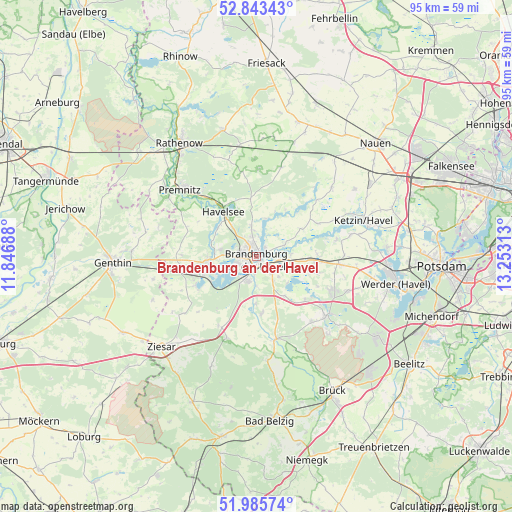
Brandenburg an der Havel GPS coordinates[2]
52° 25' 0.012" North, 12° 33' 0" East
| Map corner | latitude | longitude |
|---|---|---|
| Upper-left | 52.84343°, | 11.84688° |
| Center: | 52.41667°, | 12.55° |
| Lower-right: | 51.98574°, | 13.25313° |
| Map W x H: | 95.4×95.4 km | = 59.3×59.3mi |
| max Lat: | 55.01917° ⇑23.6% North |
| Brandenburg an der Havel: | 52.41667° |
| min Lat: | ⇓76.4% South 47.40724° |
| min Long | Brandenburg an | max Long |
| 5.92978° | 12.55° | 14.98853° |
| W 88.3%⇐ | ⇒11.7% E |
Elevation
Elevation of Brandenburg an der Havel is 57 m = 187 ft, and this is 192.1 m = 630 ft below average elevation for this country.
| Max E: |
1256 m = 4121 ft | 76.7% |
| Avg. | 249.1 m = 817 ft | |
| Brandenburg an der Havel | 57 m = 187 ft | |
Min E: |
-5 m = -16 ft | 23.3% |
See also: Brandenburg an der Havel elevation on elevation.city.
Geographical zone
Brandenburg an der Havel is located in North temperate zone (between Tropic of Cancer and the Arctic Circle). Distance of this North polar circle is 1573 km =977.4 mi to North.| Distance of | km | miles | from Brandenburg an der Havel |
|---|---|---|---|
| North Pole | 4178.9 | 2596.6 | to North |
| Arctic Circle | 1573 | 977.4 | to North |
| Tropic Cancer | 3222.3 | 2002.2 | to South |
| Equator | 5828.2 | 3621.5 | to South |


Nearby cities:
15 places around Brandenburg an der Havel: (largest is in red/bold)
• Bensdorf
14.7 km =9.1 mi,  270°
270°
• Golzow
16 km =9.9 mi,  167°
167°
• Groß Kreutz
15.6 km =9.7 mi,  95°
95°
• Kade
19.7 km =12.2 mi,  257°
257°
• Karow
21 km =13 mi,  247°
247°
• Ketzin
21.1 km =13.1 mi,  71°
71°
• Kloster Lehnin
16.9 km =10.5 mi,  129°
129°
• Nennhausen
20.7 km =12.9 mi,  350°
350°
• Premnitz
18.7 km =11.6 mi,  313°
313°
• Päwesin
15.8 km =9.8 mi,  45°
45°
• Roskow
13 km =8.1 mi,  61°
61°
• Schlagenthin
19.1 km =11.9 mi,  286°
286°
• Wenzlow
14.6 km =9.1 mi,  207°
207°
• Wollin
15.9 km =9.9 mi,  200°
200°
• Wusterwitz
12.5 km =7.8 mi,  243°
243°
In other languages:
- In Spanish: Ciudad de Brandeburgo
- In France: Brandebourg-sur-la-Havel
- In Italian: Brandeburgo sulla Havel
- In Russian: Бранденбург, Бранденбург-на-Хафеле
- In Chinese: 哈弗尔河畔勃兰登堡
Sources, notices
• [Note1] Compared only with cities in Germany existing in our database
• [Src1] Map data: © OpenStreetMap contributors (CC-BY-SA)
• [Src2] Other city data from geonames.org with taken over terms of usage.
• [Src3] Geographical zone / Annual Mean Temperature by Robert A. Rohde @ Wikipedia
