Gleichamberg geodata
Gleichamberg (Thuringia) is a populated place; located in Germany in Europe/Berlin (GMT+2) time zone. With population of 2,997 people, there are 4000 cities with bigger population in this country. Compared to other cities in Germany, 55.2% of cities are located further ↑North; 60.7% of cities are located further ←West and 66% of cities have lower elevation than Gleichamberg. Note1


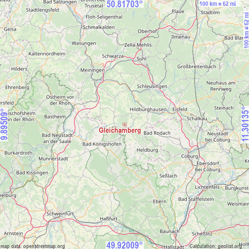
Gleichamberg GPS coordinates[2]
50° 22' 14.448" North, 10° 35' 53.592" East
| Map corner | latitude | longitude |
|---|---|---|
| Upper-left | 50.81703°, | 9.89509° |
| Center: | 50.37068°, | 10.59822° |
| Lower-right: | 49.92009°, | 11.30135° |
| Map W x H: | 99.7×99.7 km | = 62×62mi |
| max Lat: | 55.01917° ⇑55.2% North |
| Gleichamberg: | 50.37068° |
| min Lat: | ⇓44.8% South 47.40724° |
| min Long | Gleichamberg | max Long |
| 5.92978° | 10.59822° | 14.98853° |
| W 60.7%⇐ | ⇒39.3% E |
Elevation
Elevation of Gleichamberg is 328 m = 1076 ft, and this is 78.9 m = 259 ft above average elevation for this country.
| Max E: |
1256 m = 4121 ft | 34% |
| Gleichamberg | 328 m 1076 ft | |
| Avg. | 249.1 m = 817 ft | |
Min E: |
-5 m = -16 ft | 66% |
See also: Germany elevation on elevation.city.
Geographical zone
Gleichamberg is located in North temperate zone (between Tropic of Cancer and the Arctic Circle). Distance of this North polar circle is 1800.5 km =1118.8 mi to North.| Distance of | km | miles | from Gleichamberg |
|---|---|---|---|
| North Pole | 4406.4 | 2738 | to North |
| Arctic Circle | 1800.5 | 1118.8 | to North |
| Tropic Cancer | 2994.8 | 1860.9 | to South |
| Equator | 5600.7 | 3480.1 | to South |


Nearby cities:
15 places around Gleichamberg: (largest is in red/bold)
• Aubstadt
12.4 km =7.7 mi,  250°
250°
• Bad Königshofen im Grabfeld
12 km =7.5 mi,  229°
229°
• Beinerstadt
10.7 km =6.6 mi,  0°
0°
• Dingsleben
7 km =4.3 mi, 1°
• Exdorf
10.4 km =6.5 mi,  337°
337°
• Gompertshausen
8.2 km =5.1 mi,  166°
166°
• Grimmelshausen
12.8 km =8 mi,  11°
11°
• Herbstadt
8.1 km =5 mi,  239°
239°
• Hildburghausen
11.3 km =7 mi,  57°
57°
• Höchheim
10.5 km =6.5 mi,  267°
267°
• Milz
4.4 km =2.7 mi,  280°
280°
• Reurieth
9.6 km =6 mi,  22°
22°
• Römhild
5.1 km =3.2 mi,  304°
304°
• Trappstadt
6.1 km =3.8 mi,  199°
199°
• Westhausen
7.6 km =4.7 mi,  143°
143°
Sources, notices
• [Note1] Compared only with cities in Germany existing in our database
• [Src1] Map data: © OpenStreetMap contributors (CC-BY-SA)
• [Src2] Other city data from geonames.org with taken over terms of usage.
• [Src3] Geographical zone / Annual Mean Temperature by Robert A. Rohde @ Wikipedia
