Kirchberg an der Murr geodata
Kirchberg an der Murr (Baden-Württemberg) is a seat of a fourth-order administrative division; located in Germany in Europe/Berlin (GMT+2) time zone. With population of 3,593 people, there are 3547 cities with bigger population in this country. Compared to other cities in Germany, 83.6% of cities are located further ↑North; 60.2% of cities are located further →East and 59.1% of cities have lower elevation than Kirchberg an der Murr. Note1
Administrative division(s):
- Level 1: Baden-Württemberg
- Level 2: Regierungsbezirk Stuttgart
- Level 3: Rems-Murr-Kreis
- Level 4: Kirchberg an der Murr


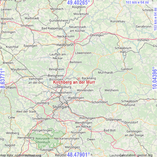
Kirchberg an der Murr GPS coordinates[2]
48° 56' 34.692" North, 9° 20' 26.988" East
| Map corner | latitude | longitude |
|---|---|---|
| Upper-left | 49.40265°, | 8.63771° |
| Center: | 48.94297°, | 9.34083° |
| Lower-right: | 48.47901°, | 10.04396° |
| Map W x H: | 102.7×102.7 km | = 63.8×63.8mi |
| max Lat: | 55.01917° ⇑83.6% North |
| Kirchberg an der Murr: | 48.94297° |
| min Lat: | ⇓16.4% South 47.40724° |
| min Long | Kirchberg an de | max Long |
| 5.92978° | 9.34083° | 14.98853° |
| W 39.8%⇐ | ⇒60.2% E |
Elevation
Elevation of Kirchberg an der Murr is 284 m = 932 ft, and this is 34.9 m = 115 ft above average elevation for this country.
| Max E: |
1256 m = 4121 ft | 40.9% |
| Kirchberg an der Murr | 284 m 932 ft | |
| Avg. | 249.1 m = 817 ft | |
Min E: |
-5 m = -16 ft | 59.1% |
See also: Germany elevation on elevation.city.
Geographical zone
Kirchberg an der Murr is located in North temperate zone (between Tropic of Cancer and the Arctic Circle). Distance of this North polar circle is 1959.2 km =1217.4 mi to North.| Distance of | km | miles | from Kirchberg an der Murr |
|---|---|---|---|
| North Pole | 4565.1 | 2836.6 | to North |
| Arctic Circle | 1959.2 | 1217.4 | to North |
| Tropic Cancer | 2836 | 1762.2 | to South |
| Equator | 5441.9 | 3381.4 | to South |


Nearby cities:
15 places around Kirchberg an der Murr: (largest is in red/bold)
• Affalterbach
2.6 km =1.6 mi,  209°
209°
• Aspach
5.1 km =3.2 mi,  58°
58°
• Backnang
7.1 km =4.4 mi,  85°
85°
• Benningen am Neckar
7.2 km =4.5 mi,  273°
273°
• Burgstetten
2.8 km =1.7 mi,  125°
125°
• Erdmannhausen
3.3 km =2.1 mi, 269°
• Großbottwar
7.4 km =4.6 mi,  332°
332°
• Leutenbach
7.2 km =4.5 mi,  148°
148°
• Marbach am Neckar
5.9 km =3.7 mi, 266°
• Mittelschöntal
4 km =2.5 mi,  84°
84°
• Murr
6.3 km =3.9 mi,  289°
289°
• Oberstenfeld
9.4 km =5.8 mi,  351°
351°
• Schwaikheim
7.3 km =4.5 mi,  174°
174°
• Steinheim am der Murr
5.4 km =3.4 mi,  301°
301°
• Winnenden
8.6 km =5.3 mi, 150°
Sources, notices
• [Note1] Compared only with cities in Germany existing in our database
• [Src1] Map data: © OpenStreetMap contributors (CC-BY-SA)
• [Src2] Other city data from geonames.org with taken over terms of usage.
• [Src3] Geographical zone / Annual Mean Temperature by Robert A. Rohde @ Wikipedia
