Aspach geodata
Aspach (Baden-Württemberg) is a seat of a fourth-order administrative division; located in Germany in Europe/Berlin (GMT+2) time zone. With population of 8,131 people, there are 1939 cities with bigger population in this country. Compared to other cities in Germany, 83.3% of cities are located further ↑North; 59.3% of cities are located further →East and 58.3% of cities have lower elevation than Aspach. Note1
Administrative division(s):
- Level 1: Baden-Württemberg
- Level 2: Regierungsbezirk Stuttgart
- Level 3: Rems-Murr-Kreis
- Level 4: Aspach


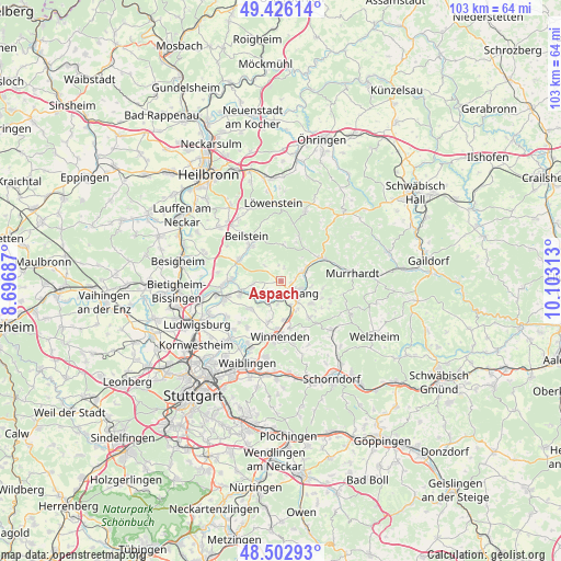
Aspach GPS coordinates[2]
48° 58' 0.012" North, 9° 24' 0" East
| Map corner | latitude | longitude |
|---|---|---|
| Upper-left | 49.42614°, | 8.69687° |
| Center: | 48.96667°, | 9.4° |
| Lower-right: | 48.50293°, | 10.10313° |
| Map W x H: | 102.7×102.6 km | = 63.8×63.8mi |
| max Lat: | 55.01917° ⇑83.3% North |
| Aspach: | 48.96667° |
| min Lat: | ⇓16.7% South 47.40724° |
| min Long | Aspach | max Long |
| 5.92978° | 9.4° | 14.98853° |
| W 40.7%⇐ | ⇒59.3% E |
Elevation
Elevation of Aspach is 280 m = 919 ft, and this is 30.9 m = 101 ft above average elevation for this country.
| Max E: |
1256 m = 4121 ft | 41.7% |
| Aspach | 280 m 919 ft | |
| Avg. | 249.1 m = 817 ft | |
Min E: |
-5 m = -16 ft | 58.3% |
See also: Germany elevation on elevation.city.
Geographical zone
Aspach is located in North temperate zone (between Tropic of Cancer and the Arctic Circle). Distance of this North polar circle is 1956.6 km =1215.8 mi to North.| Distance of | km | miles | from Aspach |
|---|---|---|---|
| North Pole | 4562.5 | 2835 | to North |
| Arctic Circle | 1956.6 | 1215.8 | to North |
| Tropic Cancer | 2838.7 | 1763.9 | to South |
| Equator | 5444.6 | 3383.1 | to South |


Nearby cities:
15 places around Aspach: (largest is in red/bold)
• Affalterbach
7.4 km =4.6 mi,  228°
228°
• Allmersbach im Tal
8.3 km =5.2 mi,  143°
143°
• Backnang
3.5 km =2.2 mi,  128°
128°
• Burgstetten
4.7 km =2.9 mi,  205°
205°
• Erdmannhausen
8 km =5 mi,  250°
250°
• Großbottwar
8.7 km =5.4 mi,  296°
296°
• Kirchberg an der Murr
5.1 km =3.2 mi,  238°
238°
• Leutenbach
8.8 km =5.5 mi,  183°
183°
• Mittelschöntal
2.3 km =1.4 mi,  188°
188°
• Oberstenfeld
8.8 km =5.5 mi,  318°
318°
• Oppenweiler
4.6 km =2.9 mi,  67°
67°
• Spiegelberg
8.9 km =5.5 mi,  21°
21°
• Steinheim am der Murr
9 km =5.6 mi,  271°
271°
• Sulzbach an der Murr
8.4 km =5.2 mi,  61°
61°
• Winnenden
10.1 km =6.3 mi, 180°
Sources, notices
• [Note1] Compared only with cities in Germany existing in our database
• [Src1] Map data: © OpenStreetMap contributors (CC-BY-SA)
• [Src2] Other city data from geonames.org with taken over terms of usage.
• [Src3] Geographical zone / Annual Mean Temperature by Robert A. Rohde @ Wikipedia
