Kestert geodata
Kestert (Rheinland-Pfalz) is a seat of a fourth-order administrative division; located in Germany in Europe/Berlin (GMT+2) time zone. With population of 745 people, there are 8126 cities with bigger population in this country. Compared to other cities in Germany, 59.4% of cities are located further ↑North; 84% of cities are located further →East and 60.9% of cities have higher elevation than Kestert. Note1


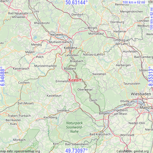
Kestert GPS coordinates[2]
50° 10' 59.988" North, 7° 39' 0" East
| Map corner | latitude | longitude |
|---|---|---|
| Upper-left | 50.63144°, | 6.94688° |
| Center: | 50.18333°, | 7.65° |
| Lower-right: | 49.73097°, | 8.35313° |
| Map W x H: | 100.1×100.1 km | = 62.2×62.2mi |
| max Lat: | 55.01917° ⇑59.4% North |
| Kestert: | 50.18333° |
| min Lat: | ⇓40.6% South 47.40724° |
| min Long | Kestert | max Long |
| 5.92978° | 7.65° | 14.98853° |
| W 16%⇐ | ⇒84% E |
Elevation
Elevation of Kestert is 146 m = 479 ft, and this is 103.1 m = 338 ft below average elevation for this country.
| Max E: |
1256 m = 4121 ft | 60.9% |
| Avg. | 249.1 m = 817 ft | |
| Kestert | 146 m = 479 ft | |
Min E: |
-5 m = -16 ft | 39.1% |
See also: Germany elevation on elevation.city.
Geographical zone
Kestert is located in North temperate zone (between Tropic of Cancer and the Arctic Circle). Distance of this North polar circle is 1821.3 km =1131.7 mi to North.| Distance of | km | miles | from Kestert |
|---|---|---|---|
| North Pole | 4427.2 | 2750.9 | to North |
| Arctic Circle | 1821.3 | 1131.7 | to North |
| Tropic Cancer | 2973.9 | 1847.9 | to South |
| Equator | 5579.9 | 3467.2 | to South |


Nearby cities:
15 places around Kestert: (largest is in red/bold)
• Boppard
6.8 km =4.2 mi,  321°
321°
• Dahlheim
4.4 km =2.7 mi,  47°
47°
• Dörth
6 km =3.7 mi,  232°
232°
• Eschbach
6.5 km =4 mi,  58°
58°
• Halsenbach
6.8 km =4.2 mi,  259°
259°
• Hungenroth
6.6 km =4.1 mi,  212°
212°
• Kamp-Bornhofen
4.8 km =3 mi,  336°
336°
• Karbach
4.4 km =2.7 mi, 212°
• Lykershausen
2.2 km =1.4 mi,  32°
32°
• Nochern
5.1 km =3.2 mi,  111°
111°
• Prath
2.8 km =1.7 mi, 60°
• Sankt Goar
5.6 km =3.5 mi,  133°
133°
• Sankt Goarshausen
5.3 km =3.3 mi,  121°
121°
• Utzenhain
5.7 km =3.5 mi,  192°
192°
• Weyer
4.7 km =2.9 mi,  90°
90°
Sources, notices
• [Note1] Compared only with cities in Germany existing in our database
• [Src1] Map data: © OpenStreetMap contributors (CC-BY-SA)
• [Src2] Other city data from geonames.org with taken over terms of usage.
• [Src3] Geographical zone / Annual Mean Temperature by Robert A. Rohde @ Wikipedia
