Boppard geodata
Boppard (Rheinland-Pfalz) is a populated place; located in Germany in Europe/Berlin (GMT+2) time zone. With population of 16,215 people, there are 980 cities with bigger population in this country. Compared to other cities in Germany, 58.4% of cities are located further ↑North; 85.2% of cities are located further →East and 71.7% of cities have higher elevation than Boppard. Note1


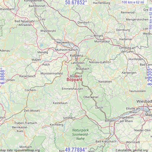
Boppard GPS coordinates[2]
50° 13' 51.06" North, 7° 35' 23.712" East
| Map corner | latitude | longitude |
|---|---|---|
| Upper-left | 50.67852°, | 6.8868° |
| Center: | 50.23085°, | 7.58992° |
| Lower-right: | 49.77894°, | 8.29305° |
| Map W x H: | 100×100 km | = 62.1×62.1mi |
| max Lat: | 55.01917° ⇑58.4% North |
| Boppard: | 50.23085° |
| min Lat: | ⇓41.6% South 47.40724° |
| min Long | Boppard | max Long |
| 5.92978° | 7.58992° | 14.98853° |
| W 14.8%⇐ | ⇒85.2% E |
Elevation
Elevation of Boppard is 80 m = 262 ft, and this is 169.1 m = 555 ft below average elevation for this country.
| Max E: |
1256 m = 4121 ft | 71.7% |
| Avg. | 249.1 m = 817 ft | |
| Boppard | 80 m = 262 ft | |
Min E: |
-5 m = -16 ft | 28.3% |
See also: Germany elevation on elevation.city.
Geographical zone
Boppard is located in North temperate zone (between Tropic of Cancer and the Arctic Circle). Distance of this North polar circle is 1816 km =1128.4 mi to North.| Distance of | km | miles | from Boppard |
|---|---|---|---|
| North Pole | 4421.9 | 2747.6 | to North |
| Arctic Circle | 1816 | 1128.4 | to North |
| Tropic Cancer | 2979.2 | 1851.2 | to South |
| Equator | 5585.1 | 3470.4 | to South |


Nearby cities:
15 places around Boppard: (largest is in red/bold)
• Braubach
6.2 km =3.9 mi,  39°
39°
• Brey
5.3 km =3.3 mi,  29°
29°
• Filsen
1.1 km =0.7 mi,  340°
340°
• Halsenbach
7 km =4.3 mi,  199°
199°
• Kamp-Bornhofen
2.6 km =1.6 mi,  110°
110°
• Kestert
6.8 km =4.2 mi,  141°
141°
• Kratzenburg
6 km =3.7 mi,  208°
208°
• Lykershausen
6.4 km =4 mi,  122°
122°
• Ney
6.6 km =4.1 mi,  217°
217°
• Nörtershausen
7.7 km =4.8 mi,  258°
258°
• Osterspai
2.2 km =1.4 mi,  46°
46°
• Prath
7.7 km =4.8 mi, 120°
• Rhens
5.9 km =3.7 mi,  19°
19°
• Spay
5.2 km =3.2 mi, 53°
• Waldesch
6.5 km =4 mi,  334°
334°
Sources, notices
• [Note1] Compared only with cities in Germany existing in our database
• [Src1] Map data: © OpenStreetMap contributors (CC-BY-SA)
• [Src2] Other city data from geonames.org with taken over terms of usage.
• [Src3] Geographical zone / Annual Mean Temperature by Robert A. Rohde @ Wikipedia
