Reichenbach geodata
Reichenbach (Thuringia) is a populated place; located in Germany in Europe/Berlin (GMT+2) time zone. With population of 992 people, there are 7213 cities with bigger population in this country. Compared to other cities in Germany, 51.7% of cities are located further ↓South; 73.3% of cities are located further ←West and 67% of cities have lower elevation than Reichenbach. Note1
Administrative division(s):
- Level 1: Thuringia
- Level 3: Saalfeld-Rudolstadt
- Level 4: Unterwellenborn


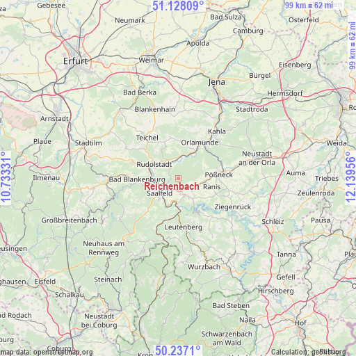
Reichenbach GPS coordinates[2]
50° 41' 4.956" North, 11° 26' 11.148" East
| Map corner | latitude | longitude |
|---|---|---|
| Upper-left | 51.12809°, | 10.73331° |
| Center: | 50.68471°, | 11.43643° |
| Lower-right: | 50.2371°, | 12.13956° |
| Map W x H: | 99.1×99.1 km | = 61.6×61.6mi |
| max Lat: | 55.01917° ⇑48.3% North |
| Reichenbach: | 50.68471° |
| min Lat: | ⇓51.7% South 47.40724° |
| min Long | Reichenbach | max Long |
| 5.92978° | 11.43643° | 14.98853° |
| W 73.3%⇐ | ⇒26.7% E |
Elevation
Elevation of Reichenbach is 335 m = 1099 ft, and this is 85.9 m = 282 ft above average elevation for this country.
| Max E: |
1256 m = 4121 ft | 33% |
| Reichenbach | 335 m 1099 ft | |
| Avg. | 249.1 m = 817 ft | |
Min E: |
-5 m = -16 ft | 67% |
See also: Germany elevation on elevation.city.
Geographical zone
Reichenbach is located in North temperate zone (between Tropic of Cancer and the Arctic Circle). Distance of this North polar circle is 1765.6 km =1097.1 mi to North.| Distance of | km | miles | from Reichenbach |
|---|---|---|---|
| North Pole | 4371.5 | 2716.3 | to North |
| Arctic Circle | 1765.6 | 1097.1 | to North |
| Tropic Cancer | 3029.7 | 1882.6 | to South |
| Equator | 5635.6 | 3501.8 | to South |


Nearby cities:
15 places around Reichenbach: (largest is in red/bold)
• Birkigt
3.8 km =2.4 mi,  116°
116°
• Goßwitz
6.2 km =3.9 mi,  152°
152°
• Herschdorf
7.7 km =4.8 mi,  67°
67°
• Hohenwarte
10 km =6.2 mi,  160°
160°
• Kamsdorf
4.8 km =3 mi,  165°
165°
• Kaulsdorf
7.6 km =4.7 mi,  181°
181°
• Krölpa
7.2 km =4.5 mi,  96°
96°
• Könitz
5.3 km =3.3 mi,  136°
136°
• Naundorf
3.3 km =2.1 mi,  326°
326°
• Ranis
9.7 km =6 mi,  105°
105°
• Rudolstadt
7.8 km =4.8 mi,  300°
300°
• Rückersdorf
6.5 km =4 mi,  25°
25°
• Saalfeld
6.4 km =4 mi,  231°
231°
• Seisla
7.9 km =4.9 mi, 118°
• Unterwellenborn
3.9 km =2.4 mi, 183°
Sources, notices
• [Note1] Compared only with cities in Germany existing in our database
• [Src1] Map data: © OpenStreetMap contributors (CC-BY-SA)
• [Src2] Other city data from geonames.org with taken over terms of usage.
• [Src3] Geographical zone / Annual Mean Temperature by Robert A. Rohde @ Wikipedia
