Saalfeld geodata
Saalfeld (Thuringia) is a seat of a third-order administrative division; located in Germany in Europe/Berlin (GMT+2) time zone. With population of 28,023 people, there are 506 cities with bigger population in this country. Compared to other cities in Germany, 50.7% of cities are located further ↓South; 72.2% of cities are located further ←West and 50.6% of cities have lower elevation than Saalfeld. Note1


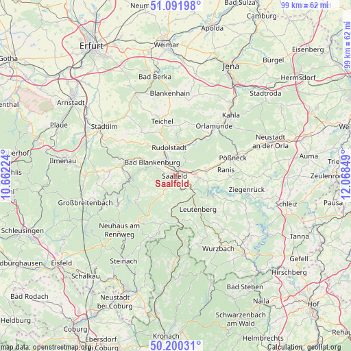
Saalfeld GPS coordinates[2]
50° 38' 53.736" North, 11° 21' 55.296" East
| Map corner | latitude | longitude |
|---|---|---|
| Upper-left | 51.09198°, | 10.66224° |
| Center: | 50.64826°, | 11.36536° |
| Lower-right: | 50.20031°, | 12.06849° |
| Map W x H: | 99.1×99.1 km | = 61.6×61.6mi |
| max Lat: | 55.01917° ⇑49.3% North |
| Saalfeld: | 50.64826° |
| min Lat: | ⇓50.7% South 47.40724° |
| min Long | Saalfeld | max Long |
| 5.92978° | 11.36536° | 14.98853° |
| W 72.2%⇐ | ⇒27.8% E |
Elevation
Elevation of Saalfeld is 230 m = 755 ft, and this is 19.1 m = 63 ft below average elevation for this country.
| Max E: |
1256 m = 4121 ft | 49.4% |
| Avg. | 249.1 m = 817 ft | |
| Saalfeld | 230 m = 755 ft | |
Min E: |
-5 m = -16 ft | 50.6% |
See also: Germany elevation on elevation.city.
Geographical zone
Saalfeld is located in North temperate zone (between Tropic of Cancer and the Arctic Circle). Distance of this North polar circle is 1769.6 km =1099.6 mi to North.| Distance of | km | miles | from Saalfeld |
|---|---|---|---|
| North Pole | 4375.5 | 2718.8 | to North |
| Arctic Circle | 1769.6 | 1099.6 | to North |
| Tropic Cancer | 3025.6 | 1880 | to South |
| Equator | 5631.6 | 3499.3 | to South |


Nearby cities:
15 places around Saalfeld: (largest is in red/bold)
• Bad Blankenburg
7.5 km =4.7 mi,  300°
300°
• Birkigt
8.7 km =5.4 mi,  74°
74°
• Döschnitz
10 km =6.2 mi,  249°
249°
• Goßwitz
8 km =5 mi,  100°
100°
• Hohenwarte
9.9 km =6.2 mi,  122°
122°
• Kamsdorf
6.3 km =3.9 mi, 95°
• Kaulsdorf
5.9 km =3.7 mi,  126°
126°
• Könitz
8.7 km =5.4 mi,  88°
88°
• Leutenberg
11.4 km =7.1 mi,  145°
145°
• Marktgölitz
10.4 km =6.5 mi,  191°
191°
• Naundorf
7.5 km =4.7 mi,  24°
24°
• Reichenbach
6.4 km =4 mi,  51°
51°
• Rudolstadt
8.2 km =5.1 mi,  347°
347°
• Unterwellenborn
4.8 km =3 mi, 87°
• Wittgendorf
10.7 km =6.6 mi,  240°
240°
In other languages:
- In German: Saalfeld/Saale
- In Italian: Saalfeld/Saale
- In Russian: Заальфельд, Зальфельд
- In Chinese: 萨尔费尔德
Sources, notices
• [Note1] Compared only with cities in Germany existing in our database
• [Src1] Map data: © OpenStreetMap contributors (CC-BY-SA)
• [Src2] Other city data from geonames.org with taken over terms of usage.
• [Src3] Geographical zone / Annual Mean Temperature by Robert A. Rohde @ Wikipedia
