Kammerstein geodata
Kammerstein (Bavaria) is a seat of a fourth-order administrative division; located in Germany in Europe/Berlin (GMT+2) time zone. With population of 2,709 people, there are 4227 cities with bigger population in this country. Compared to other cities in Germany, 78.8% of cities are located further ↑North; 66.6% of cities are located further ←West and 78.3% of cities have lower elevation than Kammerstein. Note1
Administrative division(s):
- Level 1: Bavaria
- Level 2: Regierungsbezirk Mittelfranken
- Level 3: Landkreis Roth
- Level 4: Kammerstein


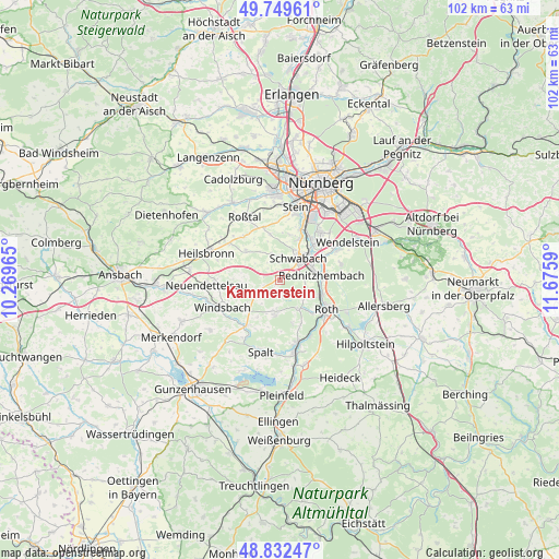
Kammerstein GPS coordinates[2]
49° 17' 35.412" North, 10° 58' 21.972" East
| Map corner | latitude | longitude |
|---|---|---|
| Upper-left | 49.74961°, | 10.26965° |
| Center: | 49.29317°, | 10.97277° |
| Lower-right: | 48.83247°, | 11.6759° |
| Map W x H: | 102×102 km | = 63.4×63.4mi |
| max Lat: | 55.01917° ⇑78.8% North |
| Kammerstein: | 49.29317° |
| min Lat: | ⇓21.2% South 47.40724° |
| min Long | Kammerstein | max Long |
| 5.92978° | 10.97277° | 14.98853° |
| W 66.6%⇐ | ⇒33.4% E |
Elevation
Elevation of Kammerstein is 422 m = 1385 ft, and this is 172.9 m = 567 ft above average elevation for this country.
| Max E: |
1256 m = 4121 ft | 21.7% |
| Kammerstein | 422 m 1385 ft | |
| Avg. | 249.1 m = 817 ft | |
Min E: |
-5 m = -16 ft | 78.3% |
See also: Germany elevation on elevation.city.
Geographical zone
Kammerstein is located in North temperate zone (between Tropic of Cancer and the Arctic Circle). Distance of this North polar circle is 1920.3 km =1193.2 mi to North.| Distance of | km | miles | from Kammerstein |
|---|---|---|---|
| North Pole | 4526.2 | 2812.4 | to North |
| Arctic Circle | 1920.3 | 1193.2 | to North |
| Tropic Cancer | 2875 | 1786.4 | to South |
| Equator | 5480.9 | 3405.7 | to South |


Nearby cities:
15 places around Kammerstein: (largest is in red/bold)
• Abenberg
5.6 km =3.5 mi,  186°
186°
• Büchenbach
6.9 km =4.3 mi,  114°
114°
• Georgensgmünd
11.9 km =7.4 mi,  164°
164°
• Heilsbronn
14.2 km =8.8 mi,  289°
289°
• Neuendettelsau
13.8 km =8.6 mi,  265°
265°
• Oberasbach
14.4 km =8.9 mi,  355°
355°
• Rednitzhembach
7.8 km =4.8 mi,  83°
83°
• Rohr
8 km =5 mi,  311°
311°
• Roth
10 km =6.2 mi,  120°
120°
• Roßtal
12.9 km =8 mi,  331°
331°
• Schwabach
5.5 km =3.4 mi,  41°
41°
• Spalt
13.5 km =8.4 mi, 194°
• Stein
14 km =8.7 mi,  12°
12°
• Wendelstein
14.5 km =9 mi,  62°
62°
• Windsbach
11.7 km =7.3 mi,  244°
244°
Sources, notices
• [Note1] Compared only with cities in Germany existing in our database
• [Src1] Map data: © OpenStreetMap contributors (CC-BY-SA)
• [Src2] Other city data from geonames.org with taken over terms of usage.
• [Src3] Geographical zone / Annual Mean Temperature by Robert A. Rohde @ Wikipedia
