Rednitzhembach geodata
Rednitzhembach (Bavaria) is a seat of a fourth-order administrative division; located in Germany in Europe/Berlin (GMT+2) time zone. With population of 7,034 people, there are 2176 cities with bigger population in this country. Compared to other cities in Germany, 78.6% of cities are located further ↑North; 68.1% of cities are located further ←West and 65.7% of cities have lower elevation than Rednitzhembach. Note1
Administrative division(s):
- Level 1: Bavaria
- Level 2: Regierungsbezirk Mittelfranken
- Level 3: Landkreis Roth
- Level 4: Rednitzhembach


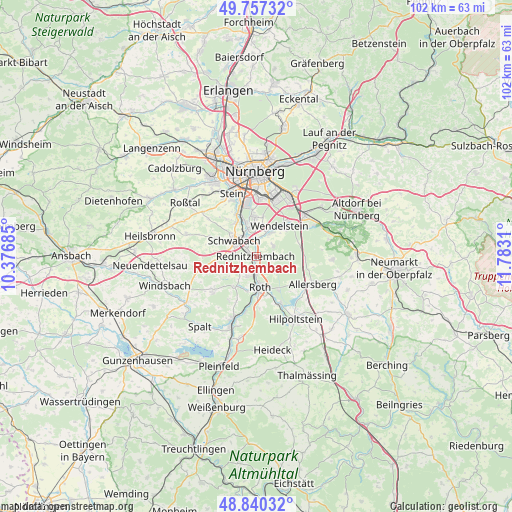
Rednitzhembach GPS coordinates[2]
49° 18' 3.42" North, 11° 4' 47.892" East
| Map corner | latitude | longitude |
|---|---|---|
| Upper-left | 49.75732°, | 10.37685° |
| Center: | 49.30095°, | 11.07997° |
| Lower-right: | 48.84032°, | 11.7831° |
| Map W x H: | 102×102 km | = 63.4×63.4mi |
| max Lat: | 55.01917° ⇑78.6% North |
| Rednitzhembach: | 49.30095° |
| min Lat: | ⇓21.4% South 47.40724° |
| min Long | Rednitzhembach | max Long |
| 5.92978° | 11.07997° | 14.98853° |
| W 68.1%⇐ | ⇒31.9% E |
Elevation
Elevation of Rednitzhembach is 326 m = 1070 ft, and this is 76.9 m = 252 ft above average elevation for this country.
| Max E: |
1256 m = 4121 ft | 34.3% |
| Rednitzhembach | 326 m 1070 ft | |
| Avg. | 249.1 m = 817 ft | |
Min E: |
-5 m = -16 ft | 65.7% |
See also: Germany elevation on elevation.city.
Geographical zone
Rednitzhembach is located in North temperate zone (between Tropic of Cancer and the Arctic Circle). Distance of this North polar circle is 1919.4 km =1192.7 mi to North.| Distance of | km | miles | from Rednitzhembach |
|---|---|---|---|
| North Pole | 4525.3 | 2811.9 | to North |
| Arctic Circle | 1919.4 | 1192.7 | to North |
| Tropic Cancer | 2875.8 | 1786.9 | to South |
| Equator | 5481.8 | 3406.2 | to South |


Nearby cities:
15 places around Rednitzhembach: (largest is in red/bold)
• Abenberg
10.6 km =6.6 mi,  232°
232°
• Allersberg
12.6 km =7.8 mi,  115°
115°
• Büchenbach
4 km =2.5 mi,  202°
202°
• Feucht
12.8 km =8 mi,  49°
49°
• Georgensgmünd
13.2 km =8.2 mi, 200°
• Großreuth bei Schweinau
15.4 km =9.6 mi,  344°
344°
• Hilpoltstein
14.7 km =9.1 mi,  146°
146°
• Kammerstein
7.8 km =4.8 mi,  263°
263°
• Pyrbaum
15 km =9.3 mi,  92°
92°
• Rohr
14.5 km =9 mi,  287°
287°
• Roth
6 km =3.7 mi,  172°
172°
• Schwabach
5.2 km =3.2 mi,  308°
308°
• Schwarzenbruck
13.4 km =8.3 mi,  61°
61°
• Stein
13.6 km =8.5 mi, 340°
• Wendelstein
7.7 km =4.8 mi,  41°
41°
Sources, notices
• [Note1] Compared only with cities in Germany existing in our database
• [Src1] Map data: © OpenStreetMap contributors (CC-BY-SA)
• [Src2] Other city data from geonames.org with taken over terms of usage.
• [Src3] Geographical zone / Annual Mean Temperature by Robert A. Rohde @ Wikipedia
