Jandelsbrunn geodata
Jandelsbrunn (Bavaria) is a seat of a fourth-order administrative division; located in Germany in Europe/Berlin (GMT+2) time zone. With population of 3,408 people, there are 3682 cities with bigger population in this country. Compared to other cities in Germany, 86.1% of cities are located further ↑North; 96.8% of cities are located further ←West and 96.1% of cities have lower elevation than Jandelsbrunn. Note1
Administrative division(s):
- Level 1: Bavaria
- Level 2: Lower Bavaria
- Level 3: Landkreis Freyung-Grafenau
- Level 4: Jandelsbrunn


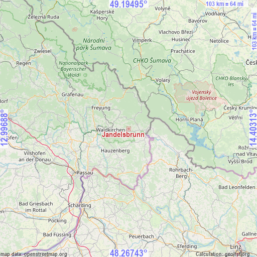
Jandelsbrunn GPS coordinates[2]
48° 43' 59.988" North, 13° 42' 0" East
| Map corner | latitude | longitude |
|---|---|---|
| Upper-left | 49.19495°, | 12.99688° |
| Center: | 48.73333°, | 13.7° |
| Lower-right: | 48.26743°, | 14.40313° |
| Map W x H: | 103.1×103.1 km | = 64.1×64.1mi |
| max Lat: | 55.01917° ⇑86.1% North |
| Jandelsbrunn: | 48.73333° |
| min Lat: | ⇓13.9% South 47.40724° |
| min Long | Jandelsbrunn | max Long |
| 5.92978° | 13.7° | 14.98853° |
| W 96.8%⇐ | ⇒3.2% E |
Elevation
Elevation of Jandelsbrunn is 630 m = 2067 ft, and this is 380.9 m = 1250 ft above average elevation for this country.
| Max E: |
1256 m = 4121 ft | 3.9% |
| Jandelsbrunn | 630 m 2067 ft | |
| Avg. | 249.1 m = 817 ft | |
Min E: |
-5 m = -16 ft | 96.1% |
See also: Germany elevation on elevation.city.
Geographical zone
Jandelsbrunn is located in North temperate zone (between Tropic of Cancer and the Arctic Circle). Distance of this North polar circle is 1982.5 km =1231.9 mi to North.| Distance of | km | miles | from Jandelsbrunn |
|---|---|---|---|
| North Pole | 4588.4 | 2851.1 | to North |
| Arctic Circle | 1982.5 | 1231.9 | to North |
| Tropic Cancer | 2812.7 | 1747.7 | to South |
| Equator | 5418.6 | 3367 | to South |


Nearby cities:
15 places around Jandelsbrunn: (largest is in red/bold)
• Breitenberg
7.6 km =4.7 mi,  115°
115°
• Büchlberg
14.8 km =9.2 mi,  242°
242°
• Freyung
14 km =8.7 mi,  307°
307°
• Fürsteneck
17.2 km =10.7 mi,  263°
263°
• Grainet
8.3 km =5.2 mi,  333°
333°
• Haidmühle
11.7 km =7.3 mi,  28°
28°
• Hauzenberg
10.8 km =6.7 mi,  210°
210°
• Hinterschmiding
12.2 km =7.6 mi,  324°
324°
• Neureichenau
3.8 km =2.4 mi,  63°
63°
• Philippsreut
14.9 km =9.3 mi,  355°
355°
• Röhrnbach
13 km =8.1 mi,  272°
272°
• Sonnen
5.7 km =3.5 mi,  167°
167°
• Untergriesbach
17.8 km =11.1 mi,  187°
187°
• Waldkirchen
7.3 km =4.5 mi, 269°
• Wegscheid
16 km =9.9 mi,  156°
156°
Sources, notices
• [Note1] Compared only with cities in Germany existing in our database
• [Src1] Map data: © OpenStreetMap contributors (CC-BY-SA)
• [Src2] Other city data from geonames.org with taken over terms of usage.
• [Src3] Geographical zone / Annual Mean Temperature by Robert A. Rohde @ Wikipedia
