Breitenberg geodata
Breitenberg (Bavaria) is a seat of a fourth-order administrative division; located in Germany in Europe/Berlin (GMT+2) time zone. With population of 2,163 people, there are 4851 cities with bigger population in this country. Compared to other cities in Germany, 86.4% of cities are located further ↑North; 97.3% of cities are located further ←West and 97.6% of cities have lower elevation than Breitenberg. Note1
Administrative division(s):
- Level 1: Bavaria
- Level 2: Lower Bavaria
- Level 3: Landkreis Passau
- Level 4: Breitenberg


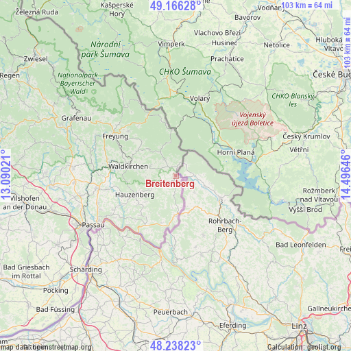
Breitenberg GPS coordinates[2]
48° 42' 15.804" North, 13° 47' 35.988" East
| Map corner | latitude | longitude |
|---|---|---|
| Upper-left | 49.16628°, | 13.09021° |
| Center: | 48.70439°, | 13.79333° |
| Lower-right: | 48.23823°, | 14.49646° |
| Map W x H: | 103.2×103.2 km | = 64.1×64.1mi |
| max Lat: | 55.01917° ⇑86.4% North |
| Breitenberg: | 48.70439° |
| min Lat: | ⇓13.6% South 47.40724° |
| min Long | Breitenberg | max Long |
| 5.92978° | 13.79333° | 14.98853° |
| W 97.3%⇐ | ⇒2.7% E |
Elevation
Elevation of Breitenberg is 690 m = 2264 ft, and this is 440.9 m = 1447 ft above average elevation for this country.
| Max E: |
1256 m = 4121 ft | 2.4% |
| Breitenberg | 690 m 2264 ft | |
| Avg. | 249.1 m = 817 ft | |
Min E: |
-5 m = -16 ft | 97.6% |
See also: Germany elevation on elevation.city.
Geographical zone
Breitenberg is located in North temperate zone (between Tropic of Cancer and the Arctic Circle). Distance of this North polar circle is 1985.8 km =1233.9 mi to North.| Distance of | km | miles | from Breitenberg |
|---|---|---|---|
| North Pole | 4591.6 | 2853.1 | to North |
| Arctic Circle | 1985.8 | 1233.9 | to North |
| Tropic Cancer | 2809.5 | 1745.7 | to South |
| Equator | 5415.4 | 3365 | to South |


Nearby cities:
15 places around Breitenberg: (largest is in red/bold)
• Büchlberg
20.3 km =12.6 mi,  259°
259°
• Grainet
14.9 km =9.3 mi,  315°
315°
• Haidmühle
13.5 km =8.4 mi,  354°
354°
• Hauzenberg
13.7 km =8.5 mi,  243°
243°
• Hinterschmiding
19.2 km =11.9 mi,  313°
313°
• Jandelsbrunn
7.6 km =4.7 mi,  295°
295°
• Neureichenau
6 km =3.7 mi,  325°
325°
• Obernzell
20.2 km =12.6 mi,  214°
214°
• Philippsreut
19.8 km =12.3 mi,  335°
335°
• Röhrnbach
20.2 km =12.6 mi,  280°
280°
• Sonnen
6.1 km =3.8 mi,  247°
247°
• Thyrnau
21.4 km =13.3 mi, 242°
• Untergriesbach
17.2 km =10.7 mi, 212°
• Waldkirchen
14.5 km =9 mi, 282°
• Wegscheid
11.5 km =7.1 mi,  182°
182°
Sources, notices
• [Note1] Compared only with cities in Germany existing in our database
• [Src1] Map data: © OpenStreetMap contributors (CC-BY-SA)
• [Src2] Other city data from geonames.org with taken over terms of usage.
• [Src3] Geographical zone / Annual Mean Temperature by Robert A. Rohde @ Wikipedia
