Sonnen geodata
Sonnen (Bavaria) is a seat of a fourth-order administrative division; located in Germany in Europe/Berlin (GMT+2) time zone. With population of 1,528 people, there are 5825 cities with bigger population in this country. Compared to other cities in Germany, 86.7% of cities are located further ↑North; 96.9% of cities are located further ←West and 99.2% of cities have lower elevation than Sonnen. Note1
Administrative division(s):
- Level 1: Bavaria
- Level 2: Lower Bavaria
- Level 3: Landkreis Passau
- Level 4: Sonnen


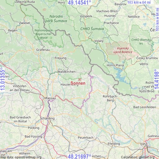
Sonnen GPS coordinates[2]
48° 40' 59.988" North, 13° 43' 0.012" East
| Map corner | latitude | longitude |
|---|---|---|
| Upper-left | 49.14541°, | 13.01355° |
| Center: | 48.68333°, | 13.71667° |
| Lower-right: | 48.21697°, | 14.4198° |
| Map W x H: | 103.2×103.2 km | = 64.1×64.1mi |
| max Lat: | 55.01917° ⇑86.7% North |
| Sonnen: | 48.68333° |
| min Lat: | ⇓13.3% South 47.40724° |
| min Long | Sonnen | max Long |
| 5.92978° | 13.71667° | 14.98853° |
| W 96.9%⇐ | ⇒3.1% E |
Elevation
Elevation of Sonnen is 802 m = 2631 ft, and this is 552.9 m = 1814 ft above average elevation for this country.
| Max E: |
1256 m = 4121 ft | 0.8% |
| Sonnen | 802 m 2631 ft | |
| Avg. | 249.1 m = 817 ft | |
Min E: |
-5 m = -16 ft | 99.2% |
See also: Germany elevation on elevation.city.
Geographical zone
Sonnen is located in North temperate zone (between Tropic of Cancer and the Arctic Circle). Distance of this North polar circle is 1988.1 km =1235.3 mi to North.| Distance of | km | miles | from Sonnen |
|---|---|---|---|
| North Pole | 4594 | 2854.6 | to North |
| Arctic Circle | 1988.1 | 1235.3 | to North |
| Tropic Cancer | 2807.2 | 1744.3 | to South |
| Equator | 5413.1 | 3363.5 | to South |


Nearby cities:
15 places around Sonnen: (largest is in red/bold)
• Breitenberg
6.1 km =3.8 mi,  67°
67°
• Büchlberg
14.4 km =8.9 mi,  264°
264°
• Grainet
13.9 km =8.6 mi,  339°
339°
• Haidmühle
16.4 km =10.2 mi,  15°
15°
• Hauzenberg
7.6 km =4.7 mi,  240°
240°
• Hinterschmiding
17.6 km =10.9 mi,  331°
331°
• Jandelsbrunn
5.7 km =3.5 mi,  347°
347°
• Neureichenau
7.6 km =4.7 mi, 17°
• Obernzell
15.4 km =9.6 mi,  202°
202°
• Röhrnbach
15.5 km =9.6 mi,  293°
293°
• Thyrnau
15.4 km =9.6 mi, 241°
• Untergriesbach
12.7 km =7.9 mi, 196°
• Waldkirchen
10.1 km =6.3 mi,  302°
302°
• Wegscheid
10.5 km =6.5 mi,  150°
150°
• Witzmannsberg
17.7 km =11 mi,  247°
247°
Sources, notices
• [Note1] Compared only with cities in Germany existing in our database
• [Src1] Map data: © OpenStreetMap contributors (CC-BY-SA)
• [Src2] Other city data from geonames.org with taken over terms of usage.
• [Src3] Geographical zone / Annual Mean Temperature by Robert A. Rohde @ Wikipedia
