Jagsthausen geodata
Jagsthausen (Baden-Württemberg) is a seat of a fourth-order administrative division; located in Germany in Europe/Berlin (GMT+2) time zone. With population of 1,500 people, there are 5880 cities with bigger population in this country. Compared to other cities in Germany, 78.5% of cities are located further ↑North; 58.3% of cities are located further →East and 51% of cities have higher elevation than Jagsthausen. Note1
Administrative division(s):
- Level 1: Baden-Württemberg
- Level 2: Regierungsbezirk Stuttgart
- Level 3: Landkreis Heilbronn
- Level 4: Jagsthausen


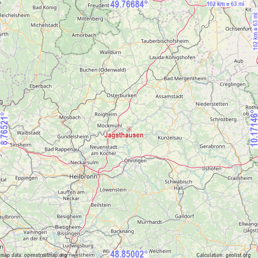
Jagsthausen GPS coordinates[2]
49° 18' 38.016" North, 9° 28' 5.988" East
| Map corner | latitude | longitude |
|---|---|---|
| Upper-left | 49.76684°, | 8.76521° |
| Center: | 49.31056°, | 9.46833° |
| Lower-right: | 48.85002°, | 10.17146° |
| Map W x H: | 101.9×101.9 km | = 63.3×63.3mi |
| max Lat: | 55.01917° ⇑78.5% North |
| Jagsthausen: | 49.31056° |
| min Lat: | ⇓21.5% South 47.40724° |
| min Long | Jagsthausen | max Long |
| 5.92978° | 9.46833° | 14.98853° |
| W 41.7%⇐ | ⇒58.3% E |
Elevation
Elevation of Jagsthausen is 218 m = 715 ft, and this is 31.1 m = 102 ft below average elevation for this country.
| Max E: |
1256 m = 4121 ft | 51% |
| Avg. | 249.1 m = 817 ft | |
| Jagsthausen | 218 m = 715 ft | |
Min E: |
-5 m = -16 ft | 49% |
See also: Germany elevation on elevation.city.
Geographical zone
Jagsthausen is located in North temperate zone (between Tropic of Cancer and the Arctic Circle). Distance of this North polar circle is 1918.4 km =1192 mi to North.| Distance of | km | miles | from Jagsthausen |
|---|---|---|---|
| North Pole | 4524.2 | 2811.2 | to North |
| Arctic Circle | 1918.4 | 1192 | to North |
| Tropic Cancer | 2876.9 | 1787.6 | to South |
| Equator | 5482.8 | 3406.9 | to South |


Nearby cities:
15 places around Jagsthausen: (largest is in red/bold)
• Adelsheim
11.5 km =7.1 mi,  331°
331°
• Forchtenberg
7.1 km =4.4 mi,  110°
110°
• Ingelfingen
13.4 km =8.3 mi,  94°
94°
• Langenbrettach
10.1 km =6.3 mi,  201°
201°
• Möckmühl
8.1 km =5 mi,  281°
281°
• Neudenau
14.5 km =9 mi,  261°
261°
• Neuenstadt am Kocher
13 km =8.1 mi,  229°
229°
• Neuenstein
14.3 km =8.9 mi,  145°
145°
• Niedernhall
10.8 km =6.7 mi,  99°
99°
• Osterburken
13.7 km =8.5 mi,  345°
345°
• Roigheim
11.1 km =6.9 mi,  302°
302°
• Weißbach
9.3 km =5.8 mi, 99°
• Widdern
3.5 km =2.2 mi, 284°
• Zweiflingen
7 km =4.3 mi, 149°
• Öhringen
12.7 km =7.9 mi,  167°
167°
Sources, notices
• [Note1] Compared only with cities in Germany existing in our database
• [Src1] Map data: © OpenStreetMap contributors (CC-BY-SA)
• [Src2] Other city data from geonames.org with taken over terms of usage.
• [Src3] Geographical zone / Annual Mean Temperature by Robert A. Rohde @ Wikipedia
