Osterburken geodata
Osterburken (Baden-Württemberg) is a populated place; located in Germany in Europe/Berlin (GMT+2) time zone. With population of 6,371 people, there are 2344 cities with bigger population in this country. Compared to other cities in Germany, 76.8% of cities are located further ↑North; 59% of cities are located further →East and 53.6% of cities have lower elevation than Osterburken. Note1
Administrative division(s):
- Level 1: Baden-Württemberg
- Level 2: Karlsruhe Region
- Level 3: Neckar-Odenwald-Kreis
- Level 4: Osterburken


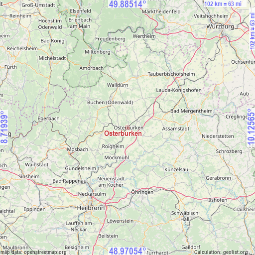
Osterburken GPS coordinates[2]
49° 25' 47.892" North, 9° 25' 21.072" East
| Map corner | latitude | longitude |
|---|---|---|
| Upper-left | 49.88514°, | 8.71939° |
| Center: | 49.42997°, | 9.42252° |
| Lower-right: | 48.97054°, | 10.12565° |
| Map W x H: | 101.7×101.7 km | = 63.2×63.2mi |
| max Lat: | 55.01917° ⇑76.8% North |
| Osterburken: | 49.42997° |
| min Lat: | ⇓23.2% South 47.40724° |
| min Long | Osterburken | max Long |
| 5.92978° | 9.42252° | 14.98853° |
| W 41%⇐ | ⇒59% E |
Elevation
Elevation of Osterburken is 250 m = 820 ft, and this is 0.90000000000001 m = 3 ft above average elevation for this country.
| Max E: |
1256 m = 4121 ft | 46.4% |
| Osterburken | 250 m 820 ft | |
| Avg. | 249.1 m = 817 ft | |
Min E: |
-5 m = -16 ft | 53.6% |
See also: Germany elevation on elevation.city.
Geographical zone
Osterburken is located in North temperate zone (between Tropic of Cancer and the Arctic Circle). Distance of this North polar circle is 1905.1 km =1183.8 mi to North.| Distance of | km | miles | from Osterburken |
|---|---|---|---|
| North Pole | 4511 | 2803 | to North |
| Arctic Circle | 1905.1 | 1183.8 | to North |
| Tropic Cancer | 2890.2 | 1795.9 | to South |
| Equator | 5496.1 | 3415.1 | to South |


Nearby cities:
15 places around Osterburken: (largest is in red/bold)
• Adelsheim
3.8 km =2.4 mi,  214°
214°
• Billigheim
15.2 km =9.4 mi,  233°
233°
• Boxberg
16.7 km =10.4 mi,  70°
70°
• Buch am Ahorn
15.5 km =9.6 mi,  38°
38°
• Buchen in Odenwald
12.7 km =7.9 mi,  325°
325°
• Forchtenberg
18.6 km =11.6 mi,  147°
147°
• Jagsthausen
13.7 km =8.5 mi,  165°
165°
• Krautheim
16.1 km =10 mi,  106°
106°
• Limbach
15.7 km =9.8 mi,  283°
283°
• Möckmühl
12.6 km =7.8 mi,  201°
201°
• Roigheim
9.4 km =5.8 mi,  219°
219°
• Rosenberg
4.6 km =2.9 mi,  51°
51°
• Seckach
6.5 km =4 mi, 282°
• Walldürn
17.6 km =10.9 mi,  346°
346°
• Widdern
12.4 km =7.7 mi,  180°
180°
Sources, notices
• [Note1] Compared only with cities in Germany existing in our database
• [Src1] Map data: © OpenStreetMap contributors (CC-BY-SA)
• [Src2] Other city data from geonames.org with taken over terms of usage.
• [Src3] Geographical zone / Annual Mean Temperature by Robert A. Rohde @ Wikipedia
