Beierstedt geodata
Beierstedt (Lower Saxony) is a seat of a fourth-order administrative division; located in Germany in Europe/Berlin (GMT+2) time zone. With population of 472 people, there are 9469 cities with bigger population in this country. Compared to other cities in Germany, 72.8% of cities are located further ↓South; 64.9% of cities are located further ←West and 69.4% of cities have higher elevation than Beierstedt. Note1


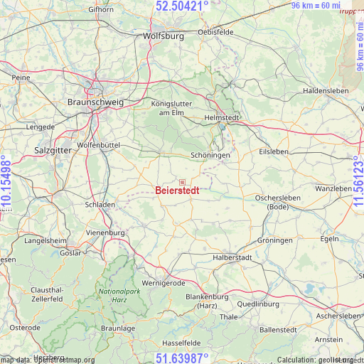
Beierstedt GPS coordinates[2]
52° 4' 26.868" North, 10° 51' 29.16" East
| Map corner | latitude | longitude |
|---|---|---|
| Upper-left | 52.50421°, | 10.15498° |
| Center: | 52.07413°, | 10.8581° |
| Lower-right: | 51.63987°, | 11.56123° |
| Map W x H: | 96.1×96.1 km | = 59.7×59.7mi |
| max Lat: | 55.01917° ⇑27.2% North |
| Beierstedt: | 52.07413° |
| min Lat: | ⇓72.8% South 47.40724° |
| min Long | Beierstedt | max Long |
| 5.92978° | 10.8581° | 14.98853° |
| W 64.9%⇐ | ⇒35.1% E |
Elevation
Elevation of Beierstedt is 95 m = 312 ft, and this is 154.1 m = 506 ft below average elevation for this country.
| Max E: |
1256 m = 4121 ft | 69.4% |
| Avg. | 249.1 m = 817 ft | |
| Beierstedt | 95 m = 312 ft | |
Min E: |
-5 m = -16 ft | 30.6% |
See also: Germany elevation on elevation.city.
Geographical zone
Beierstedt is located in North temperate zone (between Tropic of Cancer and the Arctic Circle). Distance of this North polar circle is 1611.1 km =1001.1 mi to North.| Distance of | km | miles | from Beierstedt |
|---|---|---|---|
| North Pole | 4217 | 2620.3 | to North |
| Arctic Circle | 1611.1 | 1001.1 | to North |
| Tropic Cancer | 3184.2 | 1978.6 | to South |
| Equator | 5790.1 | 3597.8 | to South |


Nearby cities:
15 places around Beierstedt: (largest is in red/bold)
• Dahlum
6.6 km =4.1 mi,  355°
355°
• Gevensleben
2.5 km =1.6 mi,  276°
276°
• Hedeper
12 km =7.5 mi,  266°
266°
• Ingeleben
3.8 km =2.4 mi,  16°
16°
• Jerxheim
2.9 km =1.8 mi,  72°
72°
• Roklum
8.1 km =5 mi,  264°
264°
• Schöningen
10.3 km =6.4 mi,  46°
46°
• Schöppenstedt
9.6 km =6 mi,  323°
323°
• Semmenstedt
11.2 km =7 mi, 281°
• Söllingen
4.9 km =3 mi, 69°
• Twieflingen
6.9 km =4.3 mi,  35°
35°
• Uehrde
6.9 km =4.3 mi,  293°
293°
• Vahlberg
11.7 km =7.3 mi,  304°
304°
• Wackersleben
11 km =6.8 mi,  92°
92°
• Winnigstedt
6.2 km =3.9 mi, 261°
Sources, notices
• [Note1] Compared only with cities in Germany existing in our database
• [Src1] Map data: © OpenStreetMap contributors (CC-BY-SA)
• [Src2] Other city data from geonames.org with taken over terms of usage.
• [Src3] Geographical zone / Annual Mean Temperature by Robert A. Rohde @ Wikipedia
