Urbach geodata
Urbach (Thuringia) is a seat of a fourth-order administrative division; located in Germany in Europe/Berlin (GMT+2) time zone. In our database, there are 11009 cities with bigger population. Compared to other cities in Germany, 66% of cities are located further ↓South; 65.5% of cities are located further ←West and 56.3% of cities have higher elevation than Urbach. Note1


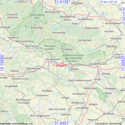
Urbach GPS coordinates[2]
51° 28' 48.36" North, 10° 54' 4.248" East
| Map corner | latitude | longitude |
|---|---|---|
| Upper-left | 51.9159°, | 10.19806° |
| Center: | 51.4801°, | 10.90118° |
| Lower-right: | 51.0401°, | 11.60431° |
| Map W x H: | 97.4×97.4 km | = 60.5×60.5mi |
| max Lat: | 55.01917° ⇑34% North |
| Urbach: | 51.4801° |
| min Lat: | ⇓66% South 47.40724° |
| min Long | Urbach | max Long |
| 5.92978° | 10.90118° | 14.98853° |
| W 65.5%⇐ | ⇒34.5% E |
Elevation
Elevation of Urbach is 179 m = 587 ft, and this is 70.1 m = 230 ft below average elevation for this country.
| Max E: |
1256 m = 4121 ft | 56.3% |
| Avg. | 249.1 m = 817 ft | |
| Urbach | 179 m = 587 ft | |
Min E: |
-5 m = -16 ft | 43.7% |
See also: Germany elevation on elevation.city.
Geographical zone
Urbach is located in North temperate zone (between Tropic of Cancer and the Arctic Circle). Distance of this North polar circle is 1677.1 km =1042.1 mi to North.| Distance of | km | miles | from Urbach |
|---|---|---|---|
| North Pole | 4283 | 2661.3 | to North |
| Arctic Circle | 1677.1 | 1042.1 | to North |
| Tropic Cancer | 3118.1 | 1937.5 | to South |
| Equator | 5724.1 | 3556.8 | to South |


Nearby cities:
15 places around Urbach: (largest is in red/bold)
• Auleben
6.3 km =3.9 mi,  161°
161°
• Badra
9.6 km =6 mi,  148°
148°
• Berga
7.8 km =4.8 mi,  110°
110°
• Breitungen
10.6 km =6.6 mi,  79°
79°
• Buchholz
6.4 km =4 mi,  338°
338°
• Görsbach
3.2 km =2 mi,  128°
128°
• Harzungen
10.6 km =6.6 mi,  322°
322°
• Heringen
4.1 km =2.5 mi,  205°
205°
• Herrmannsacker
8.1 km =5 mi, 342°
• Neustadt/Harz
10.7 km =6.6 mi,  334°
334°
• Nordhausen
7.7 km =4.8 mi,  288°
288°
• Rottleberode
5.1 km =3.2 mi,  37°
37°
• Uftrungen
5.9 km =3.7 mi,  69°
69°
• Uthleben
5.6 km =3.5 mi,  231°
231°
• Windehausen
2.5 km =1.6 mi, 230°
Sources, notices
• [Note1] Compared only with cities in Germany existing in our database
• [Src1] Map data: © OpenStreetMap contributors (CC-BY-SA)
• [Src2] Other city data from geonames.org with taken over terms of usage.
• [Src3] Geographical zone / Annual Mean Temperature by Robert A. Rohde @ Wikipedia
