Bad Mergentheim geodata
Bad Mergentheim (Baden-Württemberg) is a populated place; located in Germany in Europe/Berlin (GMT+2) time zone. With population of 22,472 people, there are 666 cities with bigger population in this country. Compared to other cities in Germany, 75.9% of cities are located further ↑North; 53.2% of cities are located further →East and 52.1% of cities have higher elevation than Bad Mergentheim. Note1
Administrative division(s):
- Level 1: Baden-Württemberg
- Level 2: Regierungsbezirk Stuttgart
- Level 3: Main-Tauber-Kreis
- Level 4: Bad Mergentheim


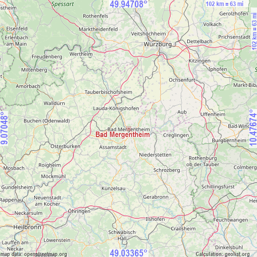
Bad Mergentheim GPS coordinates[2]
49° 29' 33" North, 9° 46' 24.996" East
| Map corner | latitude | longitude |
|---|---|---|
| Upper-left | 49.94708°, | 9.07048° |
| Center: | 49.4925°, | 9.77361° |
| Lower-right: | 49.03365°, | 10.47674° |
| Map W x H: | 101.6×101.6 km | = 63.1×63.1mi |
| max Lat: | 55.01917° ⇑75.9% North |
| Bad Mergentheim: | 49.4925° |
| min Lat: | ⇓24.1% South 47.40724° |
| min Long | Bad Mergentheim | max Long |
| 5.92978° | 9.77361° | 14.98853° |
| W 46.8%⇐ | ⇒53.2% E |
Elevation
Elevation of Bad Mergentheim is 211 m = 692 ft, and this is 38.1 m = 125 ft below average elevation for this country.
| Max E: |
1256 m = 4121 ft | 52.1% |
| Avg. | 249.1 m = 817 ft | |
| Bad Mergentheim | 211 m = 692 ft | |
Min E: |
-5 m = -16 ft | 47.9% |
See also: Germany elevation on elevation.city.
Geographical zone
Bad Mergentheim is located in North temperate zone (between Tropic of Cancer and the Arctic Circle). Distance of this North polar circle is 1898.1 km =1179.4 mi to North.| Distance of | km | miles | from Bad Mergentheim |
|---|---|---|---|
| North Pole | 4504 | 2798.7 | to North |
| Arctic Circle | 1898.1 | 1179.4 | to North |
| Tropic Cancer | 2897.1 | 1800.2 | to South |
| Equator | 5503.1 | 3419.5 | to South |


Nearby cities:
15 places around Bad Mergentheim: (largest is in red/bold)
• Assamstadt
9.6 km =6 mi,  221°
221°
• Boxberg
9.8 km =6.1 mi,  261°
261°
• Buch am Ahorn
16.6 km =10.3 mi,  288°
288°
• Bütthard
14.1 km =8.8 mi,  32°
32°
• Dörzbach
13 km =8.1 mi,  201°
201°
• Grünsfeld
13.1 km =8.1 mi,  351°
351°
• Igersheim
3.1 km =1.9 mi,  86°
86°
• Krautheim
15.3 km =9.5 mi, 220°
• Lauda-Königshofen
9.4 km =5.8 mi,  329°
329°
• Niederstetten
14.7 km =9.1 mi,  134°
134°
• Riedenheim
16.4 km =10.2 mi,  64°
64°
• Röttingen
14.4 km =8.9 mi,  82°
82°
• Tauberbischofsheim
16.7 km =10.4 mi, 331°
• Tauberrettersheim
11.8 km =7.3 mi, 88°
• Weikersheim
9.2 km =5.7 mi,  99°
99°
Sources, notices
• [Note1] Compared only with cities in Germany existing in our database
• [Src1] Map data: © OpenStreetMap contributors (CC-BY-SA)
• [Src2] Other city data from geonames.org with taken over terms of usage.
• [Src3] Geographical zone / Annual Mean Temperature by Robert A. Rohde @ Wikipedia
