Dörzbach geodata
Dörzbach (Baden-Württemberg) is a seat of a fourth-order administrative division; located in Germany in Europe/Berlin (GMT+2) time zone. With population of 2,465 people, there are 4480 cities with bigger population in this country. Compared to other cities in Germany, 77.4% of cities are located further ↑North; 54.2% of cities are located further →East and 52.7% of cities have lower elevation than Dörzbach. Note1
Administrative division(s):
- Level 1: Baden-Württemberg
- Level 2: Regierungsbezirk Stuttgart
- Level 3: Hohenlohekreis
- Level 4: Dörzbach


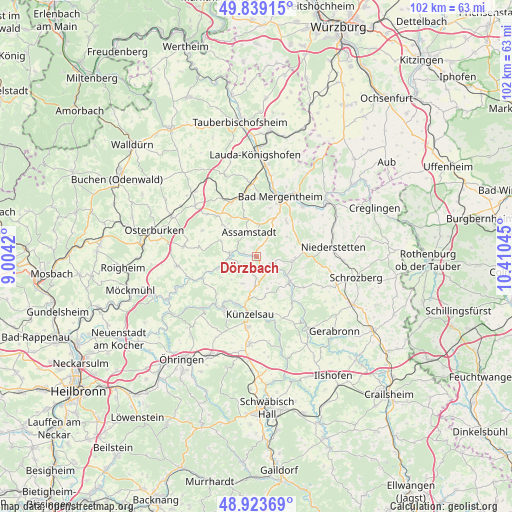
Dörzbach GPS coordinates[2]
49° 23' 0.78" North, 9° 42' 26.352" East
| Map corner | latitude | longitude |
|---|---|---|
| Upper-left | 49.83915°, | 9.0042° |
| Center: | 49.38355°, | 9.70732° |
| Lower-right: | 48.92369°, | 10.41045° |
| Map W x H: | 101.8×101.8 km | = 63.3×63.3mi |
| max Lat: | 55.01917° ⇑77.4% North |
| Dörzbach: | 49.38355° |
| min Lat: | ⇓22.6% South 47.40724° |
| min Long | Dörzbach | max Long |
| 5.92978° | 9.70732° | 14.98853° |
| W 45.8%⇐ | ⇒54.2% E |
Elevation
Elevation of Dörzbach is 244 m = 801 ft, and this is 5.1 m = 17 ft below average elevation for this country.
| Max E: |
1256 m = 4121 ft | 47.3% |
| Avg. | 249.1 m = 817 ft | |
| Dörzbach | 244 m = 801 ft | |
Min E: |
-5 m = -16 ft | 52.7% |
See also: Germany elevation on elevation.city.
Geographical zone
Dörzbach is located in North temperate zone (between Tropic of Cancer and the Arctic Circle). Distance of this North polar circle is 1910.2 km =1186.9 mi to North.| Distance of | km | miles | from Dörzbach |
|---|---|---|---|
| North Pole | 4516.1 | 2806.2 | to North |
| Arctic Circle | 1910.2 | 1186.9 | to North |
| Tropic Cancer | 2885 | 1792.7 | to South |
| Equator | 5490.9 | 3411.9 | to South |


Nearby cities:
15 places around Dörzbach: (largest is in red/bold)
• Assamstadt
5.2 km =3.2 mi,  342°
342°
• Bad Mergentheim
13 km =8.1 mi,  21°
21°
• Boxberg
11.7 km =7.3 mi, 335°
• Forchtenberg
15 km =9.3 mi,  225°
225°
• Igersheim
14.7 km =9.1 mi,  32°
32°
• Ingelfingen
10.1 km =6.3 mi,  203°
203°
• Krautheim
5.2 km =3.2 mi,  275°
275°
• Kupferzell
17.4 km =10.8 mi,  184°
184°
• Künzelsau
11.4 km =7.1 mi,  188°
188°
• Langenburg
18 km =11.2 mi,  143°
143°
• Mulfingen
8.3 km =5.2 mi,  125°
125°
• Niedernhall
11.8 km =7.3 mi,  213°
213°
• Niederstetten
15.5 km =9.6 mi,  83°
83°
• Weikersheim
17.5 km =10.9 mi,  52°
52°
• Weißbach
12.6 km =7.8 mi,  220°
220°
Sources, notices
• [Note1] Compared only with cities in Germany existing in our database
• [Src1] Map data: © OpenStreetMap contributors (CC-BY-SA)
• [Src2] Other city data from geonames.org with taken over terms of usage.
• [Src3] Geographical zone / Annual Mean Temperature by Robert A. Rohde @ Wikipedia
