Einruhr geodata
Einruhr (North Rhine-Westphalia) is a populated place; located in Germany in Europe/Berlin (GMT+2) time zone. With population of 631 people, there are 8646 cities with bigger population in this country. Compared to other cities in Germany, 50.8% of cities are located further ↑North; 98.7% of cities are located further →East and 60.7% of cities have lower elevation than Einruhr. Note1
Administrative division(s):
- Level 1: North Rhine-Westphalia
- Level 2: Regierungsbezirk Köln
- Level 3: Städteregion Aachen
- Level 4: Simmerath


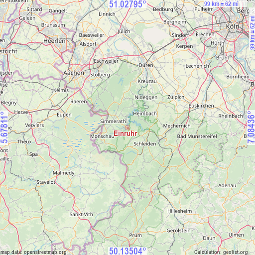
Einruhr GPS coordinates[2]
50° 35' 0.996" North, 6° 22' 52.428" East
| Map corner | latitude | longitude |
|---|---|---|
| Upper-left | 51.02795°, | 5.67811° |
| Center: | 50.58361°, | 6.38123° |
| Lower-right: | 50.13504°, | 7.08436° |
| Map W x H: | 99.3×99.3 km | = 61.7×61.7mi |
| max Lat: | 55.01917° ⇑50.8% North |
| Einruhr: | 50.58361° |
| min Lat: | ⇓49.2% South 47.40724° |
| min Long | Einruhr | max Long |
| 5.92978° | 6.38123° | 14.98853° |
| W 1.3%⇐ | ⇒98.7% E |
Elevation
Elevation of Einruhr is 294 m = 965 ft, and this is 44.9 m = 147 ft above average elevation for this country.
| Max E: |
1256 m = 4121 ft | 39.3% |
| Einruhr | 294 m 965 ft | |
| Avg. | 249.1 m = 817 ft | |
Min E: |
-5 m = -16 ft | 60.7% |
See also: Germany elevation on elevation.city.
Geographical zone
Einruhr is located in North temperate zone (between Tropic of Cancer and the Arctic Circle). Distance of this North polar circle is 1776.8 km =1104.1 mi to North.| Distance of | km | miles | from Einruhr |
|---|---|---|---|
| North Pole | 4382.7 | 2723.3 | to North |
| Arctic Circle | 1776.8 | 1104.1 | to North |
| Tropic Cancer | 3018.5 | 1875.6 | to South |
| Equator | 5624.4 | 3494.8 | to South |


Nearby cities:
15 places around Einruhr: (largest is in red/bold)
• Breinigerberg
19.8 km =12.3 mi,  329°
329°
• Heimbach
8.6 km =5.3 mi,  46°
46°
• Hellenthal
11.7 km =7.3 mi,  161°
161°
• Hürtgenwald
14.8 km =9.2 mi,  356°
356°
• Kall
13.6 km =8.5 mi,  109°
109°
• Kreuzau
19.7 km =12.2 mi,  23°
23°
• Mechernich
19.2 km =11.9 mi,  86°
86°
• Monschau
10.5 km =6.5 mi,  252°
252°
• Nettersheim
20.2 km =12.6 mi,  119°
119°
• Nideggen
14.1 km =8.8 mi,  30°
30°
• Roetgen
14.8 km =9.2 mi,  299°
299°
• Rurberg
3.3 km =2.1 mi,  0°
0°
• Schleiden
9.1 km =5.7 mi,  131°
131°
• Simmerath
6 km =3.7 mi,  287°
287°
• Vettweiß
22.7 km =14.1 mi,  42°
42°
Sources, notices
• [Note1] Compared only with cities in Germany existing in our database
• [Src1] Map data: © OpenStreetMap contributors (CC-BY-SA)
• [Src2] Other city data from geonames.org with taken over terms of usage.
• [Src3] Geographical zone / Annual Mean Temperature by Robert A. Rohde @ Wikipedia
