Simmerath geodata
Simmerath (North Rhine-Westphalia) is a seat of a fourth-order administrative division; located in Germany in Europe/Berlin (GMT+2) time zone. With population of 15,646 people, there are 1025 cities with bigger population in this country. Compared to other cities in Germany, 50.6% of cities are located further ↑North; 99.2% of cities are located further →East and 91.6% of cities have lower elevation than Simmerath. Note1
Administrative division(s):
- Level 1: North Rhine-Westphalia
- Level 2: Regierungsbezirk Köln
- Level 3: Städteregion Aachen
- Level 4: Simmerath


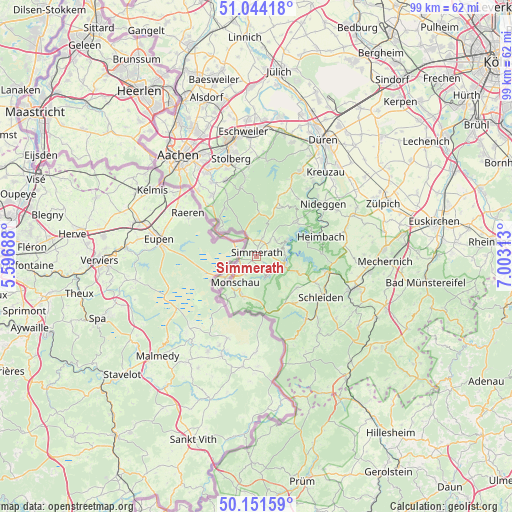
Simmerath GPS coordinates[2]
50° 36' 0" North, 6° 18' 0" East
| Map corner | latitude | longitude |
|---|---|---|
| Upper-left | 51.04418°, | 5.59688° |
| Center: | 50.6°, | 6.3° |
| Lower-right: | 50.15159°, | 7.00313° |
| Map W x H: | 99.2×99.2 km | = 61.6×61.6mi |
| max Lat: | 55.01917° ⇑50.6% North |
| Simmerath: | 50.6° |
| min Lat: | ⇓49.4% South 47.40724° |
| min Long | Simmerath | max Long |
| 5.92978° | 6.3° | 14.98853° |
| W 0.8%⇐ | ⇒99.2% E |
Elevation
Elevation of Simmerath is 536 m = 1759 ft, and this is 286.9 m = 941 ft above average elevation for this country.
| Max E: |
1256 m = 4121 ft | 8.4% |
| Simmerath | 536 m 1759 ft | |
| Avg. | 249.1 m = 817 ft | |
Min E: |
-5 m = -16 ft | 91.6% |
See also: Germany elevation on elevation.city.
Geographical zone
Simmerath is located in North temperate zone (between Tropic of Cancer and the Arctic Circle). Distance of this North polar circle is 1775 km =1102.9 mi to North.| Distance of | km | miles | from Simmerath |
|---|---|---|---|
| North Pole | 4380.9 | 2722.2 | to North |
| Arctic Circle | 1775 | 1102.9 | to North |
| Tropic Cancer | 3020.3 | 1876.7 | to South |
| Equator | 5626.2 | 3496 | to South |


Nearby cities:
15 places around Simmerath: (largest is in red/bold)
• Breinigerberg
15.8 km =9.8 mi,  344°
344°
• Einruhr
6 km =3.7 mi,  107°
107°
• Eschweiler
24.4 km =15.2 mi,  355°
355°
• Heimbach
12.6 km =7.8 mi,  70°
70°
• Hellenthal
16 km =9.9 mi,  144°
144°
• Hürtgenwald
13.8 km =8.6 mi,  19°
19°
• Kall
19.7 km =12.2 mi, 109°
• Kreuzau
21.2 km =13.2 mi,  39°
39°
• Langerwehe
24.3 km =15.1 mi,  8°
8°
• Monschau
6.6 km =4.1 mi,  220°
220°
• Nideggen
16.6 km =10.3 mi,  51°
51°
• Roetgen
9 km =5.6 mi,  308°
308°
• Rurberg
6 km =3.7 mi,  75°
75°
• Schleiden
14.8 km =9.2 mi,  122°
122°
• Stolberg
20 km =12.4 mi, 344°
Sources, notices
• [Note1] Compared only with cities in Germany existing in our database
• [Src1] Map data: © OpenStreetMap contributors (CC-BY-SA)
• [Src2] Other city data from geonames.org with taken over terms of usage.
• [Src3] Geographical zone / Annual Mean Temperature by Robert A. Rohde @ Wikipedia
