Holzbronn geodata
Holzbronn (Baden-Württemberg) is a section of populated place; located in Germany in Europe/Berlin (GMT+2) time zone. With population of 750 people, there are 8099 cities with bigger population in this country. Compared to other cities in Germany, 87% of cities are located further ↑North; 68.6% of cities are located further →East and 91.8% of cities have lower elevation than Holzbronn. Note1
Administrative division(s):
- Level 1: Baden-Württemberg
- Level 2: Karlsruhe Region
- Level 3: Landkreis Calw
- Level 4: Calw


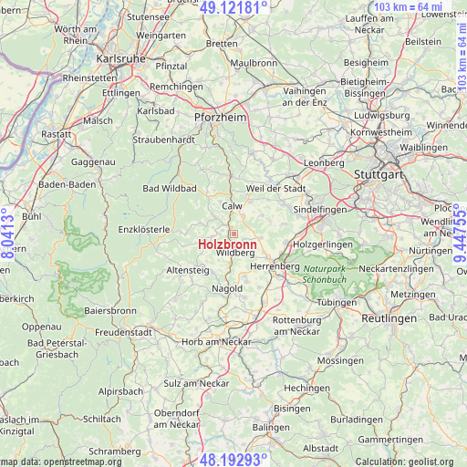
Holzbronn GPS coordinates[2]
48° 39' 34.236" North, 8° 44' 39.948" East
| Map corner | latitude | longitude |
|---|---|---|
| Upper-left | 49.12181°, | 8.0413° |
| Center: | 48.65951°, | 8.74443° |
| Lower-right: | 48.19293°, | 9.44755° |
| Map W x H: | 103.3×103.3 km | = 64.2×64.2mi |
| max Lat: | 55.01917° ⇑87% North |
| Holzbronn: | 48.65951° |
| min Lat: | ⇓13% South 47.40724° |
| min Long | Holzbronn | max Long |
| 5.92978° | 8.74443° | 14.98853° |
| W 31.4%⇐ | ⇒68.6% E |
Elevation
Elevation of Holzbronn is 540 m = 1772 ft, and this is 290.9 m = 954 ft above average elevation for this country.
| Max E: |
1256 m = 4121 ft | 8.2% |
| Holzbronn | 540 m 1772 ft | |
| Avg. | 249.1 m = 817 ft | |
Min E: |
-5 m = -16 ft | 91.8% |
See also: Germany elevation on elevation.city.
Geographical zone
Holzbronn is located in North temperate zone (between Tropic of Cancer and the Arctic Circle). Distance of this North polar circle is 1990.7 km =1237 mi to North.| Distance of | km | miles | from Holzbronn |
|---|---|---|---|
| North Pole | 4596.6 | 2856.2 | to North |
| Arctic Circle | 1990.7 | 1237 | to North |
| Tropic Cancer | 2804.5 | 1742.6 | to South |
| Equator | 5410.4 | 3361.9 | to South |


Nearby cities:
15 places around Holzbronn: (largest is in red/bold)
• Althengstett
8 km =5 mi,  27°
27°
• Bad Teinach-Zavelstein
5.1 km =3.2 mi,  312°
312°
• Calw
6.1 km =3.8 mi,  357°
357°
• Deckenpfronn
5.9 km =3.7 mi,  98°
98°
• Ebhausen
9.6 km =6 mi,  207°
207°
• Gechingen
7.4 km =4.6 mi,  57°
57°
• Neubulach
3.6 km =2.2 mi,  272°
272°
• Neuweiler
10.6 km =6.6 mi, 274°
• Oberjettingen
9.7 km =6 mi,  166°
166°
• Oberreichenbach
10 km =6.2 mi,  325°
325°
• Ostelsheim
10.6 km =6.6 mi,  45°
45°
• Rohrdorf
10.8 km =6.7 mi,  197°
197°
• Simmozheim
11.3 km =7 mi, 25°
• Unterjettingen
11.2 km =7 mi,  164°
164°
• Wildberg
4 km =2.5 mi,  179°
179°
Sources, notices
• [Note1] Compared only with cities in Germany existing in our database
• [Src1] Map data: © OpenStreetMap contributors (CC-BY-SA)
• [Src2] Other city data from geonames.org with taken over terms of usage.
• [Src3] Geographical zone / Annual Mean Temperature by Robert A. Rohde @ Wikipedia
