Calw geodata
Calw (Baden-Württemberg) is a seat of a third-order administrative division; located in Germany in Europe/Berlin (GMT+2) time zone. With population of 23,740 people, there are 630 cities with bigger population in this country. Compared to other cities in Germany, 86.3% of cities are located further ↑North; 68.7% of cities are located further →East and 67.5% of cities have lower elevation than Calw. Note1
Administrative division(s):
- Level 1: Baden-Württemberg
- Level 2: Karlsruhe Region
- Level 3: Landkreis Calw
- Level 4: Calw


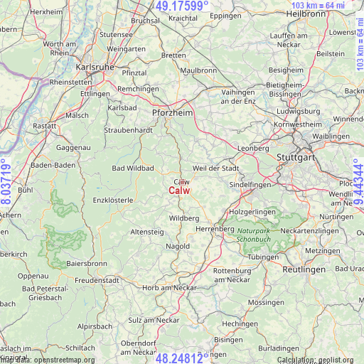
Calw GPS coordinates[2]
48° 42' 51.084" North, 8° 44' 25.116" East
| Map corner | latitude | longitude |
|---|---|---|
| Upper-left | 49.17599°, | 8.03719° |
| Center: | 48.71419°, | 8.74031° |
| Lower-right: | 48.24812°, | 9.44344° |
| Map W x H: | 103.2×103.2 km | = 64.1×64.1mi |
| max Lat: | 55.01917° ⇑86.3% North |
| Calw: | 48.71419° |
| min Lat: | ⇓13.7% South 47.40724° |
| min Long | Calw | max Long |
| 5.92978° | 8.74031° | 14.98853° |
| W 31.3%⇐ | ⇒68.7% E |
Elevation
Elevation of Calw is 339 m = 1112 ft, and this is 89.9 m = 295 ft above average elevation for this country.
| Max E: |
1256 m = 4121 ft | 32.5% |
| Calw | 339 m 1112 ft | |
| Avg. | 249.1 m = 817 ft | |
Min E: |
-5 m = -16 ft | 67.5% |
See also: Germany elevation on elevation.city.
Geographical zone
Calw is located in North temperate zone (between Tropic of Cancer and the Arctic Circle). Distance of this North polar circle is 1984.7 km =1233.2 mi to North.| Distance of | km | miles | from Calw |
|---|---|---|---|
| North Pole | 4590.6 | 2852.5 | to North |
| Arctic Circle | 1984.7 | 1233.2 | to North |
| Tropic Cancer | 2810.6 | 1746.4 | to South |
| Equator | 5416.5 | 3365.7 | to South |


Nearby cities:
15 places around Calw: (largest is in red/bold)
• Althengstett
4.1 km =2.5 mi,  75°
75°
• Bad Liebenzell
6.7 km =4.2 mi,  353°
353°
• Bad Teinach-Zavelstein
4.4 km =2.7 mi,  232°
232°
• Deckenpfronn
9.3 km =5.8 mi,  138°
138°
• Gechingen
6.8 km =4.2 mi,  107°
107°
• Holzbronn
6.1 km =3.8 mi,  177°
177°
• Neubulach
6.8 km =4.2 mi,  208°
208°
• Neuhausen
9.1 km =5.7 mi,  16°
16°
• Neuweiler
11.6 km =7.2 mi,  242°
242°
• Oberreichenbach
5.8 km =3.6 mi,  291°
291°
• Ostelsheim
8 km =5 mi, 80°
• Schömberg
10.7 km =6.6 mi,  319°
319°
• Simmozheim
6.6 km =4.1 mi,  51°
51°
• Weil der Stadt
10.4 km =6.5 mi,  67°
67°
• Wildberg
10.1 km =6.3 mi, 177°
Sources, notices
• [Note1] Compared only with cities in Germany existing in our database
• [Src1] Map data: © OpenStreetMap contributors (CC-BY-SA)
• [Src2] Other city data from geonames.org with taken over terms of usage.
• [Src3] Geographical zone / Annual Mean Temperature by Robert A. Rohde @ Wikipedia
