Bad Teinach-Zavelstein geodata
Bad Teinach-Zavelstein (Baden-Württemberg) is a populated place; located in Germany in Europe/Berlin (GMT+2) time zone. With population of 3,053 people, there are 3956 cities with bigger population in this country. Compared to other cities in Germany, 86.6% of cities are located further ↑North; 69.2% of cities are located further →East and 85% of cities have lower elevation than Bad Teinach-Zavelstein. Note1
Administrative division(s):
- Level 1: Baden-Württemberg
- Level 2: Karlsruhe Region
- Level 3: Landkreis Calw
- Level 4: Bad Teinach-Zavelstein
Current local time in Bad Teinach-Zavelstein:
03:55 PM, TuesdayDifference from your time zone: hours


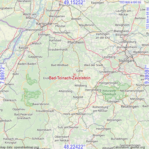
Bad Teinach-Zavelstein GPS coordinates[2]
48° 41' 25.836" North, 8° 41' 34.26" East
| Map corner | latitude | longitude |
|---|---|---|
| Upper-left | 49.15252°, | 7.98972° |
| Center: | 48.69051°, | 8.69285° |
| Lower-right: | 48.22422°, | 9.39597° |
| Map W x H: | 103.2×103.2 km | = 64.1×64.1mi |
| max Lat: | 55.01917° ⇑86.6% North |
| Bad Teinach-Zavelstein: | 48.69051° |
| min Lat: | ⇓13.4% South 47.40724° |
| min Long | Bad Teinach-Zav | max Long |
| 5.92978° | 8.69285° | 14.98853° |
| W 30.8%⇐ | ⇒69.2% E |
Elevation
Elevation of Bad Teinach-Zavelstein is 469 m = 1539 ft, and this is 219.9 m = 721 ft above average elevation for this country.
| Max E: |
1256 m = 4121 ft | 15% |
| Bad Teinach-Zavelstein | 469 m 1539 ft | |
| Avg. | 249.1 m = 817 ft | |
Min E: |
-5 m = -16 ft | 85% |
See also: Germany elevation on elevation.city.
Geographical zone
Bad Teinach-Zavelstein is located in North temperate zone (between Tropic of Cancer and the Arctic Circle). Distance of this North polar circle is 1987.3 km =1234.9 mi to North.| Distance of | km | miles | from Bad Teinach-Zavelstein |
|---|---|---|---|
| North Pole | 4593.2 | 2854.1 | to North |
| Arctic Circle | 1987.3 | 1234.9 | to North |
| Tropic Cancer | 2808 | 1744.8 | to South |
| Equator | 5413.9 | 3364 | to South |


Nearby cities:
15 places around Bad Teinach-Zavelstein: (largest is in red/bold)
• Althengstett
8.3 km =5.2 mi,  63°
63°
• Bad Liebenzell
9.7 km =6 mi,  16°
16°
• Bad Wildbad
12.4 km =7.7 mi,  302°
302°
• Calw
4.4 km =2.7 mi,  52°
52°
• Deckenpfronn
10.6 km =6.6 mi,  114°
114°
• Ebhausen
11.9 km =7.4 mi,  183°
183°
• Gechingen
10 km =6.2 mi,  86°
86°
• Holzbronn
5.1 km =3.2 mi,  132°
132°
• Neubulach
3.3 km =2.1 mi, 175°
• Neuweiler
7.3 km =4.5 mi,  248°
248°
• Oberreichenbach
5.1 km =3.2 mi,  338°
338°
• Ostelsheim
12.1 km =7.5 mi,  70°
70°
• Schömberg
11.3 km =7 mi, 341°
• Simmozheim
11 km =6.8 mi, 52°
• Wildberg
8.4 km =5.2 mi,  152°
152°
Sources, notices
• [Note1] Compared only with cities in Germany existing in our database
• [Src1] Map data: © OpenStreetMap contributors (CC-BY-SA)
• [Src2] Other city data from geonames.org with taken over terms of usage.
• [Src3] Geographical zone / Annual Mean Temperature by Robert A. Rohde @ Wikipedia
