Holleben geodata
Holleben (Saxony-Anhalt) is a populated place; located in Germany in Europe/Berlin (GMT+2) time zone. With population of 1,741 people, there are 5438 cities with bigger population in this country. Compared to other cities in Germany, 65.4% of cities are located further ↓South; 80.2% of cities are located further ←West and 71.2% of cities have higher elevation than Holleben. Note1


Holleben GPS coordinates[2]
51° 26' 25.692" North, 11° 53' 56.94" East
| Map corner | latitude | longitude |
|---|---|---|
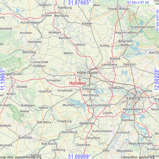
| Upper-left | 51.87665°, | 11.19603° |
| Center: | 51.44047°, | 11.89915° |
| Lower-right: | 51.00009°, | 12.60228° |
| Map W x H: | 97.5×97.5 km | = 60.6×60.6mi |
| max Lat: | 55.01917° ⇑34.6% North |
| Holleben: | 51.44047° |
| min Lat: | ⇓65.4% South 47.40724° |
| min Long | Holleben | max Long |
| 5.92978° | 11.89915° | 14.98853° |
| W 80.2%⇐ | ⇒19.8% E |
Elevation
Elevation of Holleben is 83 m = 272 ft, and this is 166.1 m = 545 ft below average elevation for this country.
| Max E: |
1256 m = 4121 ft | 71.2% |
| Avg. | 249.1 m = 817 ft | |
| Holleben | 83 m = 272 ft | |
Min E: |
-5 m = -16 ft | 28.8% |
See also: Germany elevation on elevation.city.
Geographical zone
Holleben is located in North temperate zone (between Tropic of Cancer and the Arctic Circle). Distance of this North polar circle is 1681.5 km =1044.8 mi to North.| Distance of | km | miles | from Holleben |
|---|---|---|---|
| North Pole | 4287.4 | 2664.1 | to North |
| Arctic Circle | 1681.5 | 1044.8 | to North |
| Tropic Cancer | 3113.7 | 1934.8 | to South |
| Equator | 5719.6 | 3554 | to South |


Nearby cities:
15 places around Holleben: (largest is in red/bold)
• Angersdorf
2.3 km =1.4 mi,  13°
13°
• Bad Lauchstädt
6.3 km =3.9 mi,  198°
198°
• Bennstedt
6.8 km =4.2 mi,  312°
312°
• Delitz am Berge
2.6 km =1.6 mi,  178°
178°
• Halle (Saale)
7.2 km =4.5 mi,  50°
50°
• Halle Neustadt
4.5 km =2.8 mi,  15°
15°
• Hohenweiden
3.6 km =2.2 mi,  131°
131°
• Knapendorf
7.7 km =4.8 mi,  159°
159°
• Langenbogen
9.6 km =6 mi,  299°
299°
• Lieskau
7.5 km =4.7 mi,  340°
340°
• Milzau
7.3 km =4.5 mi, 180°
• Schkopau
6.5 km =4 mi,  145°
145°
• Steuden
9.5 km =5.9 mi,  255°
255°
• Teutschenthal
7 km =4.3 mi,  278°
278°
• Zscherben
3.6 km =2.2 mi,  326°
326°
Sources, notices
• [Note1] Compared only with cities in Germany existing in our database
• [Src1] Map data: © OpenStreetMap contributors (CC-BY-SA)
• [Src2] Other city data from geonames.org with taken over terms of usage.
• [Src3] Geographical zone / Annual Mean Temperature by Robert A. Rohde @ Wikipedia
