Langenbogen geodata
Langenbogen (Saxony-Anhalt) is a populated place; located in Germany in Europe/Berlin (GMT+2) time zone. With population of 1,918 people, there are 5183 cities with bigger population in this country. Compared to other cities in Germany, 66.1% of cities are located further ↓South; 78.5% of cities are located further ←West and 70% of cities have higher elevation than Langenbogen. Note1


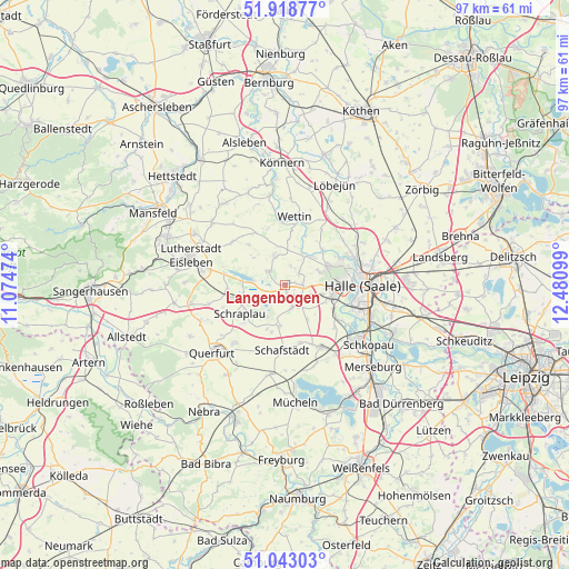
Langenbogen GPS coordinates[2]
51° 28' 58.8" North, 11° 46' 40.296" East
| Map corner | latitude | longitude |
|---|---|---|
| Upper-left | 51.91877°, | 11.07474° |
| Center: | 51.483°, | 11.77786° |
| Lower-right: | 51.04303°, | 12.48099° |
| Map W x H: | 97.4×97.4 km | = 60.5×60.5mi |
| max Lat: | 55.01917° ⇑33.9% North |
| Langenbogen: | 51.483° |
| min Lat: | ⇓66.1% South 47.40724° |
| min Long | Langenbogen | max Long |
| 5.92978° | 11.77786° | 14.98853° |
| W 78.5%⇐ | ⇒21.5% E |
Elevation
Elevation of Langenbogen is 91 m = 299 ft, and this is 158.1 m = 519 ft below average elevation for this country.
| Max E: |
1256 m = 4121 ft | 70% |
| Avg. | 249.1 m = 817 ft | |
| Langenbogen | 91 m = 299 ft | |
Min E: |
-5 m = -16 ft | 30% |
See also: Germany elevation on elevation.city.
Geographical zone
Langenbogen is located in North temperate zone (between Tropic of Cancer and the Arctic Circle). Distance of this North polar circle is 1676.8 km =1041.9 mi to North.| Distance of | km | miles | from Langenbogen |
|---|---|---|---|
| North Pole | 4282.7 | 2661.1 | to North |
| Arctic Circle | 1676.8 | 1041.9 | to North |
| Tropic Cancer | 3118.5 | 1937.7 | to South |
| Equator | 5724.4 | 3557 | to South |


Nearby cities:
15 places around Langenbogen: (largest is in red/bold)
• Amsdorf
4.1 km =2.5 mi,  239°
239°
• Bennstedt
3.3 km =2.1 mi,  91°
91°
• Dornstedt
8.3 km =5.2 mi,  195°
195°
• Höhnstedt
3.5 km =2.2 mi,  308°
308°
• Lieskau
6.3 km =3.9 mi,  68°
68°
• Röblingen am See
7.1 km =4.4 mi,  248°
248°
• Salzmünde
5.9 km =3.7 mi,  34°
34°
• Schochwitz
5.6 km =3.5 mi,  343°
343°
• Seeburg
5.3 km =3.3 mi,  278°
278°
• Stedten
7.4 km =4.6 mi,  232°
232°
• Steuden
7.2 km =4.5 mi,  186°
186°
• Teutschenthal
4 km =2.5 mi,  157°
157°
• Wansleben
3.1 km =1.9 mi,  216°
216°
• Zappendorf
3.3 km =2.1 mi,  21°
21°
• Zscherben
6.7 km =4.2 mi,  105°
105°
Sources, notices
• [Note1] Compared only with cities in Germany existing in our database
• [Src1] Map data: © OpenStreetMap contributors (CC-BY-SA)
• [Src2] Other city data from geonames.org with taken over terms of usage.
• [Src3] Geographical zone / Annual Mean Temperature by Robert A. Rohde @ Wikipedia
