Teutschenthal geodata
Teutschenthal (Saxony-Anhalt) is a seat of a fourth-order administrative division; located in Germany in Europe/Berlin (GMT+2) time zone. With population of 6,996 people, there are 2183 cities with bigger population in this country. Compared to other cities in Germany, 65.5% of cities are located further ↓South; 78.8% of cities are located further ←West and 65.2% of cities have higher elevation than Teutschenthal. Note1


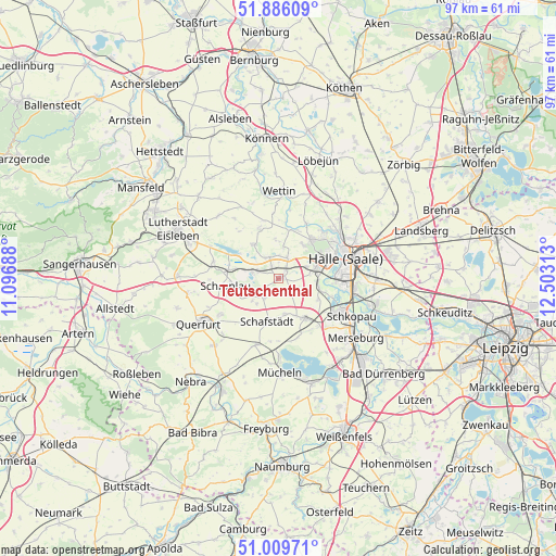
Teutschenthal GPS coordinates[2]
51° 27' 0" North, 11° 48' 0" East
| Map corner | latitude | longitude |
|---|---|---|
| Upper-left | 51.88609°, | 11.09688° |
| Center: | 51.45°, | 11.8° |
| Lower-right: | 51.00971°, | 12.50313° |
| Map W x H: | 97.4×97.4 km | = 60.5×60.5mi |
| max Lat: | 55.01917° ⇑34.5% North |
| Teutschenthal: | 51.45° |
| min Lat: | ⇓65.5% South 47.40724° |
| min Long | Teutschenthal | max Long |
| 5.92978° | 11.8° | 14.98853° |
| W 78.8%⇐ | ⇒21.2% E |
Elevation
Elevation of Teutschenthal is 119 m = 390 ft, and this is 130.1 m = 427 ft below average elevation for this country.
| Max E: |
1256 m = 4121 ft | 65.2% |
| Avg. | 249.1 m = 817 ft | |
| Teutschenthal | 119 m = 390 ft | |
Min E: |
-5 m = -16 ft | 34.8% |
See also: Germany elevation on elevation.city.
Geographical zone
Teutschenthal is located in North temperate zone (between Tropic of Cancer and the Arctic Circle). Distance of this North polar circle is 1680.5 km =1044.2 mi to North.| Distance of | km | miles | from Teutschenthal |
|---|---|---|---|
| North Pole | 4286.4 | 2663.4 | to North |
| Arctic Circle | 1680.5 | 1044.2 | to North |
| Tropic Cancer | 3114.8 | 1935.4 | to South |
| Equator | 5720.7 | 3554.7 | to South |


Nearby cities:
15 places around Teutschenthal: (largest is in red/bold)
• Amsdorf
5.3 km =3.3 mi,  287°
287°
• Angersdorf
7.5 km =4.7 mi,  81°
81°
• Bennstedt
4 km =2.5 mi,  27°
27°
• Delitz am Berge
7.9 km =4.9 mi,  117°
117°
• Dornstedt
5.8 km =3.6 mi,  220°
220°
• Holleben
7 km =4.3 mi,  98°
98°
• Höhnstedt
7.2 km =4.5 mi,  323°
323°
• Langenbogen
4 km =2.5 mi,  337°
337°
• Lieskau
7.4 km =4.6 mi,  35°
35°
• Schafstädt
7.9 km =4.9 mi,  193°
193°
• Stedten
7.5 km =4.7 mi,  264°
264°
• Steuden
4.2 km =2.6 mi,  214°
214°
• Wansleben
3.6 km =2.2 mi, 288°
• Zappendorf
6.7 km =4.2 mi,  357°
357°
• Zscherben
5.2 km =3.2 mi,  68°
68°
Sources, notices
• [Note1] Compared only with cities in Germany existing in our database
• [Src1] Map data: © OpenStreetMap contributors (CC-BY-SA)
• [Src2] Other city data from geonames.org with taken over terms of usage.
• [Src3] Geographical zone / Annual Mean Temperature by Robert A. Rohde @ Wikipedia
