Steuden geodata
Steuden (Saxony-Anhalt) is a populated place; located in Germany in Europe/Berlin (GMT+2) time zone. With population of 984 people, there are 7241 cities with bigger population in this country. Compared to other cities in Germany, 65.1% of cities are located further ↓South; 78.3% of cities are located further ←West and 63.2% of cities have higher elevation than Steuden. Note1


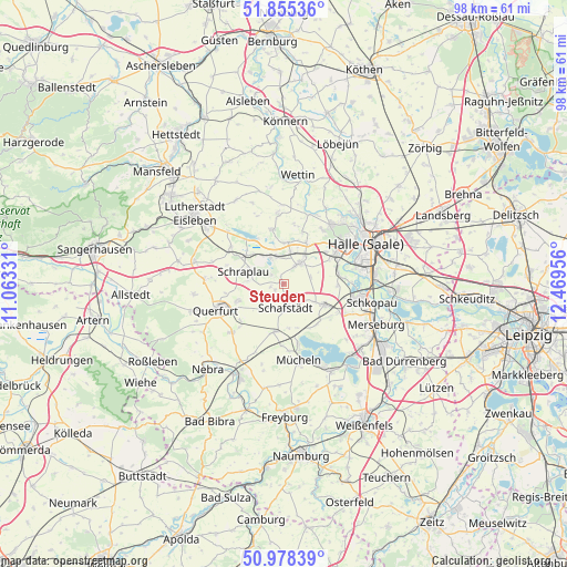
Steuden GPS coordinates[2]
51° 25' 8.328" North, 11° 45' 59.148" East
| Map corner | latitude | longitude |
|---|---|---|
| Upper-left | 51.85536°, | 11.06331° |
| Center: | 51.41898°, | 11.76643° |
| Lower-right: | 50.97839°, | 12.46956° |
| Map W x H: | 97.5×97.5 km | = 60.6×60.6mi |
| max Lat: | 55.01917° ⇑34.9% North |
| Steuden: | 51.41898° |
| min Lat: | ⇓65.1% South 47.40724° |
| min Long | Steuden | max Long |
| 5.92978° | 11.76643° | 14.98853° |
| W 78.3%⇐ | ⇒21.7% E |
Elevation
Elevation of Steuden is 131 m = 430 ft, and this is 118.1 m = 387 ft below average elevation for this country.
| Max E: |
1256 m = 4121 ft | 63.2% |
| Avg. | 249.1 m = 817 ft | |
| Steuden | 131 m = 430 ft | |
Min E: |
-5 m = -16 ft | 36.8% |
See also: Germany elevation on elevation.city.
Geographical zone
Steuden is located in North temperate zone (between Tropic of Cancer and the Arctic Circle). Distance of this North polar circle is 1683.9 km =1046.3 mi to North.| Distance of | km | miles | from Steuden |
|---|---|---|---|
| North Pole | 4289.8 | 2665.6 | to North |
| Arctic Circle | 1683.9 | 1046.3 | to North |
| Tropic Cancer | 3111.3 | 1933.3 | to South |
| Equator | 5717.3 | 3552.6 | to South |


Nearby cities:
15 places around Steuden: (largest is in red/bold)
• Amsdorf
5.8 km =3.6 mi,  331°
331°
• Bad Lauchstädt
8 km =5 mi,  116°
116°
• Bennstedt
8.1 km =5 mi,  30°
30°
• Dornstedt
1.7 km =1.1 mi,  237°
237°
• Esperstedt
6.1 km =3.8 mi,  275°
275°
• Langenbogen
7.2 km =4.5 mi,  6°
6°
• Langeneichstädt
8.3 km =5.2 mi,  191°
191°
• Obhausen
8.4 km =5.2 mi,  248°
248°
• Röblingen am See
7.4 km =4.6 mi,  307°
307°
• Schafstädt
4.2 km =2.6 mi,  173°
173°
• Schraplau
7.1 km =4.4 mi,  286°
286°
• Stedten
5.8 km =3.6 mi,  297°
297°
• Teutschenthal
4.2 km =2.6 mi, 34°
• Wansleben
4.7 km =2.9 mi,  347°
347°
• Zscherben
9 km =5.6 mi,  53°
53°
Sources, notices
• [Note1] Compared only with cities in Germany existing in our database
• [Src1] Map data: © OpenStreetMap contributors (CC-BY-SA)
• [Src2] Other city data from geonames.org with taken over terms of usage.
• [Src3] Geographical zone / Annual Mean Temperature by Robert A. Rohde @ Wikipedia
