Holle geodata
Holle (Lower Saxony) is a seat of a fourth-order administrative division; located in Germany in Europe/Berlin (GMT+2) time zone. With population of 7,349 people, there are 2101 cities with bigger population in this country. Compared to other cities in Germany, 72.9% of cities are located further ↓South; 52.6% of cities are located further ←West and 66.5% of cities have higher elevation than Holle. Note1


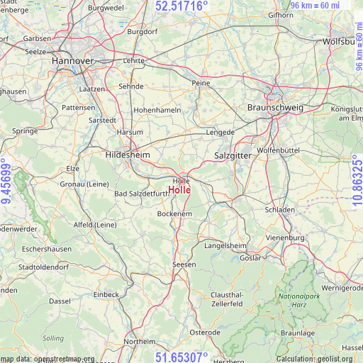
Holle GPS coordinates[2]
52° 5' 13.956" North, 10° 9' 36.432" East
| Map corner | latitude | longitude |
|---|---|---|
| Upper-left | 52.51716°, | 9.45699° |
| Center: | 52.08721°, | 10.16012° |
| Lower-right: | 51.65307°, | 10.86325° |
| Map W x H: | 96.1×96.1 km | = 59.7×59.7mi |
| max Lat: | 55.01917° ⇑27.1% North |
| Holle: | 52.08721° |
| min Lat: | ⇓72.9% South 47.40724° |
| min Long | Holle | max Long |
| 5.92978° | 10.16012° | 14.98853° |
| W 52.6%⇐ | ⇒47.4% E |
Elevation
Elevation of Holle is 111 m = 364 ft, and this is 138.1 m = 453 ft below average elevation for this country.
| Max E: |
1256 m = 4121 ft | 66.5% |
| Avg. | 249.1 m = 817 ft | |
| Holle | 111 m = 364 ft | |
Min E: |
-5 m = -16 ft | 33.5% |
See also: Germany elevation on elevation.city.
Geographical zone
Holle is located in North temperate zone (between Tropic of Cancer and the Arctic Circle). Distance of this North polar circle is 1609.6 km =1000.2 mi to North.| Distance of | km | miles | from Holle |
|---|---|---|---|
| North Pole | 4215.5 | 2619.4 | to North |
| Arctic Circle | 1609.6 | 1000.2 | to North |
| Tropic Cancer | 3185.6 | 1979.4 | to South |
| Equator | 5791.6 | 3598.7 | to South |


Nearby cities:
15 places around Holle: (largest is in red/bold)
• Almstedt
14.9 km =9.3 mi,  245°
245°
• Alt Wallmoden
12.3 km =7.6 mi,  127°
127°
• Bad Salzdetfurth
11 km =6.8 mi, 252°
• Baddeckenstedt
5 km =3.1 mi,  94°
94°
• Bockenem
8.8 km =5.5 mi,  192°
192°
• Burgdorf
7.5 km =4.7 mi,  31°
31°
• Elbe
8.4 km =5.2 mi, 92°
• Haverlah
2.3 km =1.4 mi,  168°
168°
• Heere
6.6 km =4.1 mi,  110°
110°
• Lutter am Barenberge
13.2 km =8.2 mi,  145°
145°
• Neuhof
13.8 km =8.6 mi,  213°
213°
• Schellerten
11.6 km =7.2 mi,  340°
340°
• Sehlde
9 km =5.6 mi, 126°
• Sehlem
15.1 km =9.4 mi,  236°
236°
• Söhlde
12.3 km =7.6 mi,  23°
23°
Sources, notices
• [Note1] Compared only with cities in Germany existing in our database
• [Src1] Map data: © OpenStreetMap contributors (CC-BY-SA)
• [Src2] Other city data from geonames.org with taken over terms of usage.
• [Src3] Geographical zone / Annual Mean Temperature by Robert A. Rohde @ Wikipedia
